
Nikoi Island地形图
点击地图以显示海拔。
关于这张地图
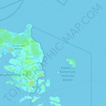
名称:Nikoi Island地形图、海拔、地势。
地点:Nikoi Island, Bintan, Riau Islands, Sumatra, Indonesia (0.73190 104.38959 1.37190 105.02959)
平均海拔:3 米
最低海拔:-4 米
最高海拔:314 米
其他地形图
点击地图以查看其地形、其海拔和其地势。
Bintan Island
Indonesia > Riau Islands > Bintan
Bintan, is the largest among the 3,200 islands of Riau Archipelago and is located 10 kilometres (6.2 mi) east of the Batam Island. It has a coast line of 105 kilometres (65 mi) and has rolling topography in its landform. The Riau Islands are a province of Indonesia, which encompassed the Riau Archipelago,…
平均海拔:6 米