
Mount Lamborn地形图
点击地图以显示海拔。
关于这张地图
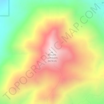
名称:Mount Lamborn地形图、海拔、地势。
地点:Mount Lamborn, Delta County, Colorado, United States (38.80300 -107.52288 38.80310 -107.52278)
平均海拔:2,949 米
最低海拔:2,427 米
最高海拔:3,460 米
其他地形图
点击地图以查看其地形、其海拔和其地势。
Cedaredge
United States > Colorado > Delta County
Located in a protected valley at 6,100 feet (1,900 m) in elevation, the Cedaredge Golf Club course has natural cedars and winding creek beds.
平均海拔:1,883 米
Cedaredge
United States > Colorado > Delta County
Located in a protected valley at 6,100 feet (1,900 m) in elevation, the Cedaredge Golf Club course has natural cedars and winding creek beds.
平均海拔:1,883 米
Cedaredge
United States > Colorado > Delta County
Located in a protected valley at 6,100 feet (1,900 m) in elevation, the Cedaredge Golf Club course has natural cedars and winding creek beds.
平均海拔:1,883 米
Cedaredge
United States > Colorado > Delta County
Located in a protected valley at 6,100 feet (1,900 m) in elevation, the Cedaredge Golf Club course has natural cedars and winding creek beds.
平均海拔:1,883 米