Touwsberg地形图
点击地图以显示海拔。
关于这张地图
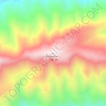
名称:Touwsberg地形图、海拔、地势。
地点:Touwsberg, George, Western Cape, South Africa (-33.56044 20.96584 -33.56034 20.96594)
平均海拔:1,125 米
最低海拔:729 米
最高海拔:1,481 米
其他地形图
点击地图以查看其地形、其海拔和其地势。

点击地图以显示海拔。
名称:Touwsberg地形图、海拔、地势。
地点:Touwsberg, George, Western Cape, South Africa (-33.56044 20.96584 -33.56034 20.96594)
平均海拔:1,125 米
最低海拔:729 米
最高海拔:1,481 米
点击地图以查看其地形、其海拔和其地势。