
Poteau Mountain地形图
点击地图以显示海拔。
关于这张地图
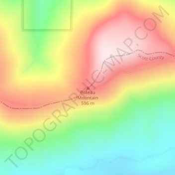
名称:Poteau Mountain地形图、海拔、地势。
地点:Poteau Mountain, Sebastian County, Arkansas, United States (34.95005 -94.33360 34.95015 -94.33350)
平均海拔:455 米
最低海拔:237 米
最高海拔:687 米
其他地形图
点击地图以查看其地形、其海拔和其地势。
Fort Smith
United States > Arkansas > Sebastian County
The United States acquired the territory and large areas west of the Mississippi River from France in the Louisiana Purchase (1803). Soon after, the government sent the Pike Expedition (1806) to explore the areas along the Arkansas River. The US founded Fort Smith in 1817 as a military post. It was named after…
平均海拔:140 米
Fort Smith
United States > Arkansas > Sebastian County
The United States acquired this territory and large areas west of the Mississippi River from France in the Louisiana Purchase (1803). Soon after, the government sent the Pike Expedition (1806) to explore the areas along the Arkansas River. The US founded Fort Smith in 1817 as a military post. It was named…
平均海拔:140 米