
The Brothers地形图
点击地图以显示海拔。
关于这张地图
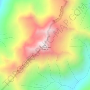
名称:The Brothers地形图、海拔、地势。
地点:The Brothers, Jefferson County, Washington, United States (47.65370 -123.14049 47.65380 -123.14039)
平均海拔:1,469 米
最低海拔:891 米
最高海拔:2,064 米
其他地形图
点击地图以查看其地形、其海拔和其地势。
Hoh River
United States > Washington > Jefferson County
The Hoh River Trail, managed by the National Park Service, begins at the national park's Hoh Rain Forest Visitor Center at the end of the Upper Hoh Road. The trail follows the Hoh River east into the heart of the park. After 17.5 mi (28.2 km) it reaches Glacier Meadows near Mount Olympus's Blue Glacier. The…
平均海拔:534 米
Hoh River
United States > Washington > Jefferson County
The Hoh River Trail, managed by the National Park Service, begins at the national park's Hoh Rain Forest Visitor Center at the end of the Upper Hoh Road. The trail follows the Hoh River east into the heart of the park. After 17.5 mi (28.2 km) it reaches Glacier Meadows near Mount Olympus's Blue Glacier. The…
平均海拔:531 米