
Tondong地形图
点击地图以显示海拔。
关于这张地图
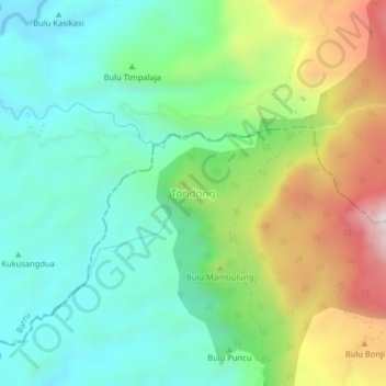
名称:Tondong地形图、海拔、地势。
地点:Tondong, South Sulawesi, Sulawesi, Indonesia (-4.77991 119.75562 -4.73991 119.79562)
平均海拔:523 米
最低海拔:248 米
最高海拔:1,085 米
其他地形图
点击地图以查看其地形、其海拔和其地势。
Tana Toraja Regency
Tana Toraja is centrally placed in the island of Sulawesi, 300 km north of Makassar, the provincial capital of South Sulawesi. It lies between latitude of 2°-3° South and longitude 119°-120° East (center: 3°S 120°E / 3°S 120°E / -3; 120). The total area (since the separation of the new regency…
平均海拔:1,316 米
Somba Opu
The total area is 28.09 km2 or 2,809 Ha (1.49% of the total area of Gowa Regency) with an altitude of 25 metres above sea level. Most of the area is located in the lowlands with geographic coordinates at 5°12'5"S 119°27'15"E. The natural border with the neighbouring district of Pallangga is the Jeneberang…
平均海拔:10 米
Jeneponto
Jeneponto Regency (Makasar: ᨍᨙᨊᨙᨄᨚᨈᨚ, romanized: Je’ne’ponto, Makasar pronunciation: [ɟʝeʔ.nep.ˈpʰɔn.t̪ʰɔ]) is a regency of South Sulawesi Province of Indonesia. It covers most of the south coast of the southern peninsula of Sulawesi, with a total area of 796.00 km2 and a…
平均海拔:145 米