
Idyllwild地形图
点击地图以显示海拔。
关于这张地图
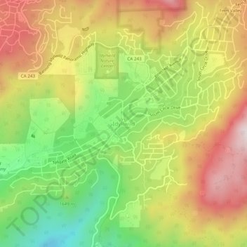
名称:Idyllwild地形图、海拔、地势。
平均海拔:1,709 米
最低海拔:1,377 米
最高海拔:2,042 米
其他地形图
点击地图以查看其地形、其海拔和其地势。
Palm Springs
United States > California > Riverside County
One possible origin of palm in the place name comes from early Spanish explorers who referred to the area as La Palma de la Mano de Dios or "The Palm of God's hand". The earliest use of the name "Palm Springs" is from United States Topographical Engineers who used the term in 1853 maps. According to William…
平均海拔:859 米
Coachella
United States > California > Riverside County
The elevation is 68 feet (21 m) below sea level, as the eastern half of the Coachella Valley is below sea level. The saltwater lake, Salton Sea, 10 miles (16 km) south of Coachella, is 228 feet (69 m) below sea level.
平均海拔:2 米
Menifee
United States > California > Riverside County
The city is centrally located in Southern California in the Menifee Valley. It is almost 15 miles (24 km) north of Temecula and just north of Murrieta. Menifee is roughly 46 square miles (100 km2) in size and has an elevation of 1,424 feet (434 m). The incorporated City of Menifee includes the communities of…
平均海拔:471 米
Riverside
United States > California > Riverside County
Riverside is the 59th-most populous city in the United States, the 12th-most populous city in California, and the largest city in California's Inland Empire metro area. According to the United States Census Bureau, the city has an area of 81.4 square miles (210.8 km2), of which 81.1 square miles (210 km2) is…
平均海拔:371 米
Palm Desert
United States > California > Riverside County
The elevation (City hall) is 224 feet (68 m) above sea level. Elevations vary from the lower northern half once covered in sand dunes to the upper slope southern cove (300–900 feet or 91–274 metres) all the way to the ridgeline at 1,000 feet (300 m). Palm Desert is located in the Coachella Valley, the…
平均海拔:178 米
Riverside
United States > California > Riverside County
Riverside is the 59th-most populous city in the United States, the 12th-most populous city in California, and the largest city in California's Inland Empire metro area. According to the United States Census Bureau, the city has an area of 81.4 square miles (210.8 km2), of which 81.1 square miles (210 km2) is…
平均海拔:371 米
La Quinta
United States > California > Riverside County
La Quinta is located at 33°40′31″N 116°17′51″W / 33.67528°N 116.29750°W / 33.67528; -116.29750 (33.675373, −116.297391). According to the United States Census Bureau, the city has a total area of 35.6 square miles (92 km2), of which 35.1 square miles (91 km2) is land and 0.4 square miles…
平均海拔:201 米
Thermal
United States > California > Riverside County > Thermal
Thermal is an unincorporated community within the Coachella Valley in Riverside County, California, United States, located approximately 25 miles (40 km) southeast of Palm Springs and about 9.5 miles (15.3 km) north of the Salton Sea. The community's elevation is 138 feet (42 m) below mean sea level. It is…
平均海拔:-35 米
La Quinta
United States > California > Riverside County
According to the United States Census Bureau, the city has a total area of 35.6 square miles (92 km2), of which 35.1 square miles (91 km2) is land and 0.4 square miles (1.0 km2) (1.22%) is water. The city's elevation is 56 feet (20 m) above sea level.
平均海拔:201 米
Mountain Center
United States > California > Riverside County > Idyllwild
It lies centered on the junction of State Route 74 and State Route 243 in the southern division of San Bernardino National Forest. Mountain Center lies just north of Lake Hemet, midway between Hemet and Palm Desert, just south of the town of Idyllwild, and it is southeast of the city of Riverside, the county…
平均海拔:1,475 米
Banning
United States > California > Riverside County
Banning's elevation is approximately 2,300 feet (700 m) above sea level, which gives it a cooler climate in contrast to the county seat of Riverside at 800 feet (240 m) above sea level and the Coachella Valley of the Colorado Desert to the east.
平均海拔:1,036 米
Menifee
United States > California > Riverside County
The city is centrally located in Southern California in the Menifee Valley. It is almost 15 miles (24 km) north of Temecula and just north of Murrieta. Menifee is roughly 46 square miles (100 km2) in size and has an elevation of 1,424 feet (434 m). The incorporated City of Menifee includes the communities of…
平均海拔:474 米
Mesa Verde
United States > California > Riverside County
Mesa Verde (Spanish for 'Green Table') is a census-designated place in Riverside County, California. Mesa Verde sits at an elevation of 390 feet (120 m). The 2020 United States census reported Mesa Verde's population was 766.
平均海拔:120 米
Aguanga
United States > California > Riverside County
Aguanga (/əˈwɑːŋ.ɡə/; Luiseño: Awáanga, meaning "dog place") is a census-designated place located within the Inland Empire in Riverside County, California. It is located about 18 miles (29 km) east of Temecula and 22 miles (35 km) south-southeast of Hemet. Aguanga lies at an elevation of 1955 feet…
平均海拔:725 米
La Quinta
United States > California > Riverside County
According to the United States Census Bureau, the city has a total area of 35.6 square miles (92 km2), of which 35.1 square miles (91 km2) is land and 0.4 square miles (1.0 km2) (1.22%) is water. The city's elevation is 56 feet (20 m) above sea level.
平均海拔:201 米
Palm Springs
United States > California > Riverside County
One possible origin of palm in the place name comes from early Spanish explorers who referred to the area as La Palma de la Mano de Dios or "The Palm of God's hand". The earliest use of the name "Palm Springs" is from United States Topographical Engineers who used the term in 1853 maps. According to William…
平均海拔:859 米
Hemet
United States > California > Riverside County
Dedicated to James Simpson, Hemet City Council from 1947 to 48, and mayor from 1950 to 1966, Simpson Park is a wilderness park located in the Santa Rosa Hills southeast of Hemet with sheltered picnic area and tables, barbecues, restrooms, and hiking trails. At an elevation of 2,500 feet (760 m), it provides an…
平均海拔:535 米
Banning
United States > California > Riverside County
Banning's elevation is approximately 2,300 feet (700 m) above sea level, which gives it a cooler climate in contrast to the county seat of Riverside at 800 feet (240 m) above sea level and the Coachella Valley of the Colorado Desert to the east.
平均海拔:1,036 米
Hemet
United States > California > Riverside County
Dedicated to James Simpson, Hemet City Council from 1947 to 48, and mayor from 1950 to 1966, Simpson Park is a wilderness park located in the Santa Rosa Hills southeast of Hemet with sheltered picnic area and tables, barbecues, restrooms, and hiking trails. At an elevation of 2,500 feet (760 m), it provides an…
平均海拔:535 米
Menifee
United States > California > Riverside County
The city is centrally located in Southern California in the Menifee Valley. It is almost 15 miles (24 km) north of Temecula and just north of Murrieta. Menifee is roughly 46 square miles (100 km2) in size and has an elevation of 1,424 feet (434 m). The incorporated City of Menifee includes the communities of…
平均海拔:474 米
Mountain Center
United States > California > Riverside County > Idyllwild
It lies centered on the junction of State Route 74 and State Route 243 in the southern division of San Bernardino National Forest. Mountain Center lies just north of Lake Hemet, midway between Hemet and Palm Desert, just south of the town of Idyllwild, and it is southeast of the city of Riverside, the county…
平均海拔:1,475 米
Menifee
United States > California > Riverside County
The city is centrally located in Southern California in the Menifee Valley. It is almost 15 miles (24 km) north of Temecula and just north of Murrieta. Menifee is roughly 46 square miles (100 km2) in size and has an elevation of 1,424 feet (434 m). The incorporated City of Menifee includes the communities of…
平均海拔:474 米
Anza
United States > California > Riverside County > Anza
Anza is a census-designated place in Riverside County, California, in the Anza Valley, a semi-arid region at a mean elevation of 3,921 feet (1,195 m) above sea level. It is located 13 miles (21 km) south of Idyllwild, 32 miles (51 km) east-northeast of Temecula, 40 miles (64 km) southwest of Palm Springs, and…
平均海拔:1,309 米
Idyllwild-Pine Cove
United States > California > Riverside County > Idyllwild
"Mile-high Idyllwild" is a mountain resort about one-mile (1,600 m) in altitude. Idyllwild is flanked by two large rock formations, Tahquitz Peak and Suicide Rock, which are famous in Southern California rock-climbing circles. It offers no skiing, so "the Hill" has been minimally developed over the years and…
平均海拔:1,712 米
Cherry Valley
United States > California > Riverside County
With an elevation of 2,980 feet above sea level, Cherry Valley is at the highest point on the San Gorgonio Pass between San Bernardino and Palm Springs. According to the United States Census Bureau, the CDP has a total area of 8.1 square miles (21 km2), all of it land.
平均海拔:933 米
Anza
United States > California > Riverside County > Anza
Anza is a census-designated place located in southwestern Riverside County, California, in the Anza Valley, a semi-arid region at a mean elevation of 3,921 feet (1,195 m) above sea level. It is located 13 miles (21 km) south of Idyllwild, 32 miles (51 km) east-northeast of Temecula, 40 miles (64 km) southwest…
平均海拔:1,309 米
Thermal
United States > California > Riverside County > Thermal
Thermal is an unincorporated community within the Coachella Valley in Riverside County, California, United States, located approximately 25 miles (40 km) southeast of Palm Springs and about 9.5 miles (15.3 km) north of the Salton Sea. The community's elevation is 138 feet (42 m) below mean sea level. It is…
平均海拔:-35 米
Beaumont
United States > California > Riverside County
With an elevation of 2,500 to 3,000 feet (760 to 910 m) above sea level, Beaumont is at the peak on the San Gorgonio Pass between San Bernardino and Palm Springs, neighboring the Interstate 10 and State Route 60 freeways. If driving east to Banning or west to Calimesa, drivers can feel a gradual downward slope.
平均海拔:730 米
Coachella
United States > California > Riverside County
The elevation is 68 feet (21 m) below sea level, as the eastern half of the Coachella Valley is below sea level. The saltwater lake, Salton Sea, 10 miles (16 km) south of Coachella, is 228 feet (69 m) below sea level.
平均海拔:2 米
Banning
United States > California > Riverside County
Banning's elevation is approximately 2,300 feet (700 m) above sea level, which gives it a cooler climate in contrast to the county seat of Riverside at 800 feet (240 m) above sea level and the Coachella Valley of the Colorado Desert to the east.
平均海拔:1,036 米
Calimesa
United States > California > Riverside County
Situated within the foothills of the San Bernardino Mountains, the city's elevation ranges between 2,300 to 3,500 feet (700 to 1,070 m) above sea level.
平均海拔:720 米
Palm Springs
United States > California > Riverside County
One possible origin of palm in the place name comes from early Spanish explorers who referred to the area as La Palma de la Mano de Dios or "The Palm of God's hand". The earliest use of the name "Palm Springs" is from United States Topographical Engineers who used the term in 1853 maps. According to William…
平均海拔:859 米
Cherry Valley
United States > California > Riverside County > Beaumont
With an elevation of 2,980 feet above sea level, Cherry Valley is at the highest point on the San Gorgonio Pass between San Bernardino and Palm Springs. According to the United States Census Bureau, the CDP has a total area of 8.1 square miles (21 km2), all of it land.
平均海拔:942 米
Palm Desert
United States > California > Riverside County > Palm Desert
The elevation (at City Hall) is 224 feet (68 m) above sea level. Elevations vary from the lower northern half once covered in sand dunes to the upper slope southern cove (300–900 feet or 91–274 metres) all the way to the ridgeline at 1,000 feet (300 m). Palm Desert is in the Coachella Valley, the…
平均海拔:303 米
Lake Mathews
United States > California > Riverside County
Lake Mathews was constructed in a basin formerly traversed by Cajalco Creek; thus, any water flowing down the creek enters the reservoir. Cajalco Creek is a tributary of the Santa Ana River via Cajalco Canyon Creek into Temescal Creek. The original course of the creek, before 1933, can be seen on the US Dept.…
平均海拔:430 米
Mountain Center
United States > California > Riverside County
It lies centered on the junction of State Route 74 and State Route 243 in the southern division of San Bernardino National Forest. Mountain Center lies just north of Lake Hemet, midway between Hemet and Palm Desert, just south of the town of Idyllwild, and it is southeast of the city of Riverside, the county…
平均海拔:1,476 米
Menifee
United States > California > Riverside County
The city is centrally located in Southern California in the Menifee Valley. It is almost 15 miles (24 km) north of Temecula and just north of Murrieta. Menifee is roughly 46 square miles (100 km2) in size and has an elevation of 1,424 feet (434 m). The incorporated City of Menifee includes the communities of…
平均海拔:474 米
Colorado River
United States > California > Riverside County > Blythe
The entire eastern boundary of the Colorado River Basin runs along the North American Continental Divide and is defined largely by the Rocky Mountains. The Wind River Range in Wyoming marks the northern extent of the basin, and is separated from the Colorado Rockies by the endorheic Great Divide Basin in…
平均海拔:102 米
El Cerrito
United States > California > Riverside County
According to the United States Census Bureau, the city has a total area of 3.7 square miles (9.6 km2), all of it land. The city ranges in elevation from 20 to 934 feet, with an average elevation of 69 feet (21 m).
平均海拔:293 米
Coachella
United States > California > Riverside County
The elevation is 68 feet (21 m) below sea level, as the eastern half of the Coachella Valley is below sea level. The saltwater lake, Salton Sea, 10 miles (16 km) south of Coachella, is 228 feet (69 m) below sea level.
平均海拔:2 米
Colorado River
United States > California > Riverside County > Blythe
The entire eastern boundary of the Colorado River Basin runs along the North American Continental Divide and is defined largely by the Rocky Mountains and the Rio Grande Basin. The Wind River Range in Wyoming marks the northern extent of the basin, and is separated from the Colorado Rockies by the endorheic…
平均海拔:102 米
Lake Elsinore
United States > California > Riverside County
The rainfall until 1893 was greater than normal, and the lake remained high and overflowed naturally on three or four occasions during that time. The lake water was purchased by the Temescal Water Company for the irrigation of land in Corona. Its outlet channel was deepened, permitting gravity flow down the…
平均海拔:531 米
Palm Desert
United States > California > Riverside County
The elevation (at City Hall) is 224 feet (68 m) above sea level. Elevations vary from the lower northern half once covered in sand dunes to the upper slope southern cove (300–900 feet or 91–274 metres) all the way to the ridgeline at 1,000 feet (300 m). Palm Desert is in the Coachella Valley, the…
平均海拔:178 米
Riverside
United States > California > Riverside County
Riverside is the 61st-largest city in the United States, the 12th-largest city in California, and the largest city in California's Inland Empire metro area. According to the United States Census Bureau, the city has an area of 81.4 square miles (210.8 km2), of which 81.1 square miles (210 km2) is land and 0.3…
平均海拔:371 米
Idyllwild-Pine Cove
United States > California > Riverside County
"Mile-high Idyllwild" is a mountain resort about one mile (1600 m) in altitude. Idyllwild is flanked by two large rock formations, Tahquitz Rock (also known as Lily Rock) and Suicide Rock, which are famous in Southern California rock-climbing circles.[citation needed] It offers no skiing, so "the Hill" has…
平均海拔:1,746 米