
Hucknall地形图
点击地图以显示海拔。
Hucknall
Hucknall Airfield, built in 1916, became RAF Hucknall. From 1927, Rolls-Royce began using the airfield for flight tests. During World War II, the aerodrome at Hucknall launched the first flight of a P-51 Mustang fitted with a Rolls-Royce Merlin Engine. The Merlin, replacing the earlier Allison V-1710 engine, allowed the Mustang air frame to reach its full potential and achieve spectacular high-altitude performance.
关于这张地图
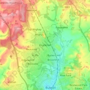
名称:Hucknall地形图、海拔、地势。
平均海拔:105 米
最低海拔:45 米
最高海拔:186 米
其他地形图
点击地图以查看其地形、其海拔和其地势。