
Stavanger地形图
点击地图以显示海拔。
Stavanger
The municipality of Stavanger is located in a coastal landscape, bordering the sea to the west and Boknafjorden in the northeast. The Byfjorden and Gandsfjorden run along the east side of the city. It is part of the Low-Jæren, a flat area of land consisting mostly of marsh, sand, and stone aur, that ranges from Ogna River in the south to Tungenes in the north; it is the northernmost part that includes Stavanger. The majority of the municipality lies between 0 and 50 m (0 and 164 ft) in elevation. The landscape has a distinctive appearance with rocks and hills where there is no settlement or agriculture. The city of Stavanger is closely linked to the sea and water, with five lakes (including Breiavatnet, Stora Stokkavatnet, and Mosvatnet) and three fjords (Hafrsfjorden, Byfjorden, and Gandsfjorden); sea and water form the landscape, providing a shoreline rich with vegetation and wildlife.
关于这张地图
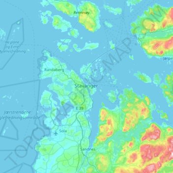
名称:Stavanger地形图、海拔、地势。
地点:Stavanger, Rogaland, 4006, Norway (58.80997 5.57181 59.12997 5.89181)
平均海拔:44 米
最低海拔:-1 米
最高海拔:552 米
其他地形图
点击地图以查看其地形、其海拔和其地势。
Stavanger
The municipality of Stavanger is located in a coastal landscape, bordering the sea to the west and Boknafjorden in the northeast. The Byfjorden and Gandsfjorden run along the east side of the city. It is part of the Low-Jæren, a flat area of land consisting mostly of marsh, sand, and stone aur, that ranges…
平均海拔:42 米
Stavanger
The municipality of Stavanger is located in a coastal landscape, bordering the sea to the west and Boknafjorden in the northeast. The Byfjorden and Gandsfjorden run along the east side of the city. It is part of the Low-Jæren, a flat area of land consisting mostly of marsh, sand, and stone aur, that ranges…
平均海拔:37 米
Stavanger
The municipality of Stavanger is located in a coastal landscape, bordering the sea to the west and Boknafjorden in the northeast. The Byfjorden and Gandsfjorden run along the east side of the city. It is part of the Low-Jæren, a flat area of land consisting mostly of marsh, sand, and stone aur, that ranges…
平均海拔:42 米