
Bath地形图
点击地图以显示海拔。
Bath
Bath is in the Avon Valley and is surrounded by limestone hills as it is near the southern edge of the Cotswolds, a designated Area of Outstanding Natural Beauty, and the limestone Mendip Hills rise around 7 miles (11 km) south of the city. The hills that surround and make up the city have a maximum altitude of 781 feet (238 metres) on the Lansdown plateau. Bath has an area of 11 square miles (28 square kilometres).
关于这张地图
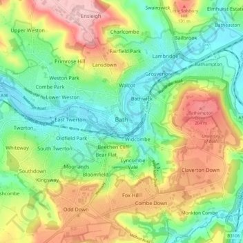
名称:Bath地形图、海拔、地势。
平均海拔:100 米
最低海拔:14 米
最高海拔:235 米
其他地形图
点击地图以查看其地形、其海拔和其地势。
Bathwick Hill
United Kingdom > England > Bath and North East Somerset > Bath
Number 1 (Bathwick Lodge) is a 2-storey villa with a steep Mansard room, built in 1825, extended in 1840 and the late C19. Probably by John Pinch the Elder.[4] Number 2 is from the early 19th century and has shutters over the windows.[11] Number 3 includes a porch which is elaborately enriched with carving,…
平均海拔:93 米
Park Corner
United Kingdom > England > Bath and North East Somerset > Freshford > Park Corner
平均海拔:93 米