
Furley地形图
点击地图以显示海拔。
关于这张地图
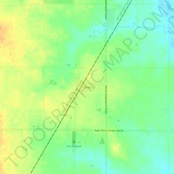
名称:Furley地形图、海拔、地势。
地点:Furley, Sedgwick County, Kansas, United States (37.85918 -97.23282 37.89918 -97.19282)
平均海拔:426 米
最低海拔:410 米
最高海拔:443 米
其他地形图
点击地图以查看其地形、其海拔和其地势。
Wichita
United States > Kansas > Sedgwick County
Wichita features a predominantly flat and gently rolling landscape characteristic of the Great Plains region. The city sits at an elevation of approximately 1,300 feet above sea level and is crisscrossed by several small rivers, including the Arkansas River, which flows through the city, providing a slight…
平均海拔:408 米
Wichita
United States > Kansas > Sedgwick County
The city lies on the Arkansas River near the western edge of the Flint Hills in the Wellington-McPherson Lowlands region of the Great Plains. The area's topography is characterized by the broad alluvial plain of the Arkansas River valley and the moderately rolling slopes that rise to the higher lands on either…
平均海拔:408 米
Goddard
United States > Kansas > Sedgwick County
Goddard is located at 37°39′35″N 97°34′27″W / 37.65972°N 97.57417°W / 37.65972; -97.57417 (37.659706, -97.574271) at an elevation of 1,463 feet (446 m). Goddard lies on U.S. Route 54 in south-central Kansas, immediately west of Wichita.
平均海拔:443 米
Wichita
United States > Kansas > Sedgwick County
The city lies on the Arkansas River near the western edge of the Flint Hills in the Wellington-McPherson Lowlands region of the Great Plains. The area's topography is characterized by the broad alluvial plain of the Arkansas River valley and the moderately rolling slopes that rise to the higher lands on either…
平均海拔:408 米