
Gandara地形图
点击地图以显示海拔。
关于这张地图
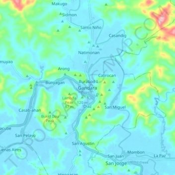
名称:Gandara地形图、海拔、地势。
地点:Gandara, Samar, Eastern Visayas, 6706, Philippines (11.97328 124.77145 12.05328 124.85145)
平均海拔:37 米
最低海拔:-6 米
最高海拔:249 米
其他地形图
点击地图以查看其地形、其海拔和其地势。
Calbayog
Forty percent of the city's land area are plain and hilly terrains with elevation ranging from 5 to 20 metres (16 to 66 ft) above sea level. The rest are rugged mountain ranges with elevations from 300 to 700 metres (980 to 2,300 ft) above sea level. Flooding is minimized because of many rivers, brooks,…
平均海拔:78 米