Upper Harbour地形图
互动地图
点击地图以显示海拔。
关于这张地图
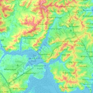
名称:Upper Harbour地形图、海拔、地势。
地点:Upper Harbour, Auckland, 新西兰 / 紐西蘭 (-36.82564 174.59115 -36.70247 174.74231)
平均海拔:42 米
最低海拔:0 米
最高海拔:138 米
其他地形图
点击地图以查看其地形、其海拔和其地势。

点击地图以显示海拔。
名称:Upper Harbour地形图、海拔、地势。
地点:Upper Harbour, Auckland, 新西兰 / 紐西蘭 (-36.82564 174.59115 -36.70247 174.74231)
平均海拔:42 米
最低海拔:0 米
最高海拔:138 米
点击地图以查看其地形、其海拔和其地势。