Ballincollig地形图
点击地图以显示海拔。
关于这张地图
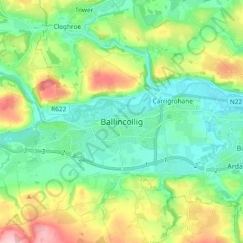
名称:Ballincollig地形图、海拔、地势。
地点:Ballincollig, Cork, County Cork, Munster, P31 TW88, Ireland (51.84834 -8.62940 51.92834 -8.54940)
平均海拔:62 米
最低海拔:2 米
最高海拔:198 米
其他地形图
点击地图以查看其地形、其海拔和其地势。

点击地图以显示海拔。
名称:Ballincollig地形图、海拔、地势。
地点:Ballincollig, Cork, County Cork, Munster, P31 TW88, Ireland (51.84834 -8.62940 51.92834 -8.54940)
平均海拔:62 米
最低海拔:2 米
最高海拔:198 米
点击地图以查看其地形、其海拔和其地势。