
Yelm地形图
点击地图以显示海拔。
关于这张地图
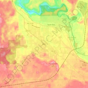
名称:Yelm地形图、海拔、地势。
地点:Yelm, Thurston County, Washington, United States (46.90139 -122.64639 46.98139 -122.56639)
平均海拔:109 米
最低海拔:34 米
最高海拔:156 米
其他地形图
点击地图以查看其地形、其海拔和其地势。
Olympia
United States > Washington > Thurston County
Olympia is characterized by a diverse topography that ranges from coastal lowlands to the gently sloping Cascade foothills to the southeast. The city is perched at an average elevation of about 150 feet above sea level, lying adjacent to Budd Inlet and surrounded by rich, green hills that rise gradually from…
平均海拔:49 米
Olympia
United States > Washington > Thurston County
The area is located near the southern limit of the Fraser Glaciation and the underlying sediments consist largely of Vashon-age till and outwash deposited at that time; the area also includes former lakebeds and alluvial deposits associated with proglacial lakes that existed in the area near the end of…
平均海拔:49 米