
Apostle Islands地形图
点击地图以显示海拔。
关于这张地图
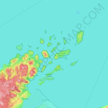
名称:Apostle Islands地形图、海拔、地势。
地点:Apostle Islands, Wisconsin, United States (46.61827 -90.97296 47.25827 -90.33296)
平均海拔:197 米
最低海拔:175 米
最高海拔:431 米
其他地形图
点击地图以查看其地形、其海拔和其地势。
Milwaukee
United States > Wisconsin > Milwaukee County
Milwaukee County is characterized by a gently rolling landscape that transitions into flatter terrain as it approaches Lake Michigan. The region's elevation varies modestly, with most areas ranging from about 600 to 700 feet above sea level. The county features several prominent water bodies, including the…
平均海拔:205 米
Madison
United States > Wisconsin > Dane County
The city is sometimes described as The City of Four Lakes, comprising the four successive lakes of the Yahara River: Lake Mendota ("Fourth Lake"), Lake Monona ("Third Lake"), Lake Waubesa ("Second Lake") and Lake Kegonsa ("First Lake"), although Waubesa and Kegonsa are not actually in Madison, but just south…
平均海拔:284 米
Dane County
Dane County showcases a diverse topography characterized by its rolling hills and numerous lakes, primarily shaped by glacial activity during the last Ice Age. The terrain varies significantly, with elevations ranging from approximately 860 feet to 1,200 feet above sea level. The county is famously known for…
平均海拔:289 米
Madison
United States > Wisconsin > Dane County
The city is sometimes described as The City of Four Lakes, comprising the four successive lakes of the Yahara River: Lake Mendota ("Fourth Lake"), Lake Monona ("Third Lake"), Lake Waubesa ("Second Lake") and Lake Kegonsa ("First Lake"), although Waubesa and Kegonsa are not actually in Madison, but just south…
平均海拔:284 米
Wausau
United States > Wisconsin > Marathon County
According to the United States Census Bureau, the city has a total area of 20.33 square miles (52.7 km2), of which 19.22 square miles (49.8 km2) is land and 1.11 square miles (2.9 km2) is water. The city is located at an altitude of 1,195 feet (364 m). Wausau is close to the center of the northern half of the…
平均海拔:394 米
Forest County
According to the U.S. Census Bureau, the county has a total area of 1,046 square miles (2,710 km2), of which 1,014 square miles (2,630 km2) is land and 32 square miles (83 km2) (3.1%) is water. The second highest elevation in the state of Wisconsin is Sugarbush hill which is in Forest County.
平均海拔:479 米
Calumet County
According to the U.S. Census Bureau, the county has a total area of 397 square miles (1,030 km2), of which 318 square miles (820 km2) is land and 79 square miles (200 km2) (20%) is water. It is the fifth-smallest county in Wisconsin by land area and fourth-smallest by total area. The west boundary is largely…
平均海拔:257 米
Door County
The 102-foot-high (31 m) Brussels Hill (44°45′06″N 87°35′27″W / 44.75166°N 87.59093°W / 44.75166; -87.59093 (Brussels Hill), elevation 851 feet [259 m]) is the highest point in the county. The nearby Red Hill Woods is the largest remaining maple–beech forest in the area.
平均海拔:202 米
Madison
United States > Wisconsin > Dane County
According to the United States Census Bureau, the city has an area of 94.03 square miles (243.54 km2), of which 76.79 square miles (198.89 km2) is land and 17.24 square miles (44.65 km2) is water. The city's lowest elevation is the intersection of Regas Road and Corporate Drive on the east side, at 836.9 ft…
平均海拔:284 米
La Crosse
United States > Wisconsin > La Crosse County
Surrounding the relatively flat prairie valley where La Crosse lies are towering 500-foot (150 m) bluffs, one of the most prominent of which is Grandad Bluff (mentioned in Life on the Mississippi by Mark Twain), which has an overlook of the three states region. This feature typifies the topography of the…
平均海拔:238 米