
Crewe Green地形图
点击地图以显示海拔。
关于这张地图
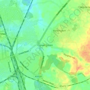
名称:Crewe Green地形图、海拔、地势。
地点:Crewe Green, Cheshire East, England, CW1 5UN, United Kingdom (53.07456 -2.42978 53.11456 -2.38978)
平均海拔:58 米
最低海拔:44 米
最高海拔:78 米
其他地形图
点击地图以查看其地形、其海拔和其地势。
Alderley Edge
United Kingdom > England > Cheshire East
Alderley Edge is 6 miles (10 km) northwest of Macclesfield and 12 miles (19 km) south of Manchester, at the base of a steep and thickly wooded sandstone escarpment, Alderley Edge, which is the area's chief topographical feature and overlooks the Cheshire Plain.
平均海拔:91 米