
Indang地形图
点击地图以显示海拔。
Indang
The topography of Indang is characterised by gently sloping or rolling terrain. Almost 40.36% of its total land area is within the slope grade of 3-8%, while 2,135 hectares is within the slope range of 8-15% which is characterised by undulating or sloping terrain.
关于这张地图
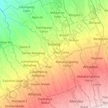
名称:Indang地形图、海拔、地势。
地点:Indang, Cavite, Calabarzon, 4122, Philippines (14.12133 120.81690 14.24643 120.92996)
平均海拔:329 米
最低海拔:81 米
最高海拔:590 米
其他地形图
点击地图以查看其地形、其海拔和其地势。
Tagaytay
The southern and eastern portions of Tagaytay are covered by hills and mountains which is generally forests, pine trees and open grasslands. The city lies along Tagaytay Ridge, a ridge stretching about 32 kilometres (20 mi) from Mount Batulao in the west to Mount Sungay in the east with elevations averaging…
平均海拔:229 米
Indang
Philippines > Cavite > Indang
The topography of Indang is characterised by gently sloping or rolling terrain. Almost 40.36% of its total land area is within the slope grade of 3-8%, while 2,135 hectares is within the slope range of 8-15% which is characterised by undulating or sloping terrain.
平均海拔:298 米
Trece Martires
The city of Trece Martires is characterised with ground elevation ranging from 30m to nearly 400m. Its ground slope ranges from 0.5 to 2%.
平均海拔:150 米
Dasmariñas
Dasmariñas is partly lowland and partly hilly. The Poblacion itself is elevated. From an elevation of 80 meters (260 ft) at the Poblacion, the land rises to 250 meters (820 ft) towards Silang. Generally, land near rivers and creeks are rugged. Dasmariñas is outside the typhoon belt and has no fault line…
平均海拔:97 米
Mount Sungay
Philippines > Cavite > Tagaytay
The mountain peak was previously much higher with an elevation of 752 meters (2,467 ft), Its former profile, "a sharp peak at the eastern end of a table of land (Tagaytay Ridge)", was one of the visible landmarks used by early navigators when sailing to and around Manila Bay. It was conical in shape with steep…
平均海拔:501 米
Dasmariñas
Dasmariñas is partly lowland and partly hilly. The Poblacion itself is elevated. From an elevation of 80 meters (260 ft) at the Poblacion, the land rises to 250 meters (820 ft) towards Silang. Generally, land near rivers and creeks are rugged. Dasmariñas is outside the typhoon belt and has no fault line…
平均海拔:97 米