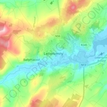
地理定位

Letterkenny地形图

点击地图以显示海拔

关于这张地图

名称Letterkenny地形图、海拔、地势。

地点Letterkenny, Letterkenny Municipal District, County Donegal, F92 PD92, Ireland (54.91179 -7.77544 54.99179 -7.69544)

平均海拔:93 米

最低海拔:-4 米

最高海拔:289 米

其他地形图

点击地图以查看其地形、其海拔和其地势

Windyhall

Ireland > County Donegal > Letterkenny > Windhall

平均海拔:118 米

Kindrum

Ireland > County Donegal > Letterkenny

平均海拔:49 米

Loughnagin

Ireland > County Donegal > Letterkenny

平均海拔:73 米

Church Hill

Ireland > County Donegal > Letterkenny

平均海拔:117 米

Ballygreen

Ireland > County Donegal > Letterkenny

平均海拔:13 米

Carrickart

Ireland > County Donegal > Letterkenny

平均海拔:71 米

Pluck

Ireland > County Donegal > Letterkenny

平均海拔:30 米

Lough Salt

Ireland > County Donegal > Letterkenny

平均海拔:246 米

Dooballagh

Ireland > County Donegal > Letterkenny

平均海拔:166 米

Letterkenny

Ireland > County Donegal > Letterkenny

平均海拔:42 米

Killydonnell

Ireland > County Donegal > Letterkenny

平均海拔:41 米

Meenlaragh

Ireland > County Donegal > Letterkenny

平均海拔:190 米

Glencar Scotch

Ireland > County Donegal > Letterkenny

平均海拔:134 米

Lisnenan

Ireland > County Donegal > Letterkenny

平均海拔:101 米

Glen Lough

Ireland > County Donegal > Letterkenny

平均海拔:89 米

Stragraddy

Ireland > County Donegal > Letterkenny

平均海拔:118 米

Church Hill

Ireland > County Donegal > Letterkenny

平均海拔:117 米

Bomany

Ireland > County Donegal > Letterkenny

平均海拔:62 米

Sallaghagrane

Ireland > County Donegal > Letterkenny

平均海拔:57 米