
Beckley地形图
点击地图以显示海拔。
Beckley
Due to its elevation, the climate of Beckley is humid subtropical (Köppen Cfa) bordering on both an oceanic (Köppen Cfb) and humid continental (Köppen Dfa/Dfb), and the city straddles the border between USDA Plant Hardiness Zones 6B and 7A. Summers are warm and humid, usually a few degrees cooler than lower-elevation places within the state, with an average of only 1.3 days of a maximum at or above 90 °F (32 °C) annually. Winters are generally cold and snowy with occasional intervening milder periods and an average of 1.4 nights annually with a minimum of 0 °F (−18 °C) or lower. Normal monthly daily mean temperatures range from 32.2 °F (0.1 °C) in January to 71.6 °F (22.0 °C) in July. Snowfall varies with an average of 55.9 inches (142 cm) per season and mostly occurs from December to March with an occasional snowfall in November of (usually) 2–3 inches (5–8 cm). Record temperatures range from −22 °F (−30 °C) on January 21, 1985, up to 103 °F (39 °C) on July 21 and August 11, 1926; the extreme coldest daily maximum was −3 °F (−19 °C) on February 13, 1899, while, conversely, the extreme warmest daily minimum was 79 °F (26 °C) on July 7, 1924 and August 22, 1926. On average, the first and last occurrences of freezing temperatures in the cooler season are October 13 and April 30, respectively, allowing for a growing season of 165 days.
关于这张地图
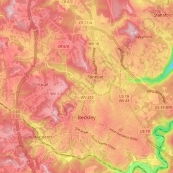
名称:Beckley地形图、海拔、地势。
地点:Beckley, Raleigh County, West Virginia, 25801, United States (37.75765 -81.22051 37.82144 -81.14191)
平均海拔:723 米
最低海拔:558 米
最高海拔:794 米
其他地形图
点击地图以查看其地形、其海拔和其地势。