
Gatton地形图
点击地图以显示海拔。
Gatton
Gatton's elevations range from 215m AOD, the highest elevation, along Fort Lane, a cul-de-sac off the intersection of Reigate Hill (M25 Junction 8) which leads to four homes over the boundary in Reigate, a radio transmitter station, and a water tower. On the A217 is the Bridge House Hotel, whose name refers to a footbridge carrying the North Downs Way across the A217 85m to the east.
关于这张地图
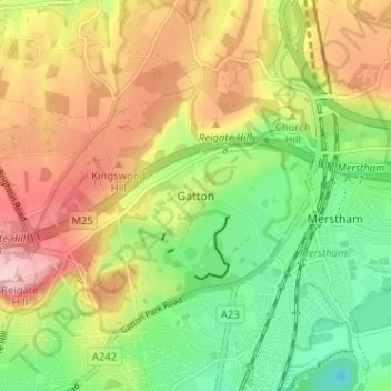
名称:Gatton地形图、海拔、地势。
平均海拔:134 米
最低海拔:46 米
最高海拔:236 米
其他地形图
点击地图以查看其地形、其海拔和其地势。
Horley
United Kingdom > England > Surrey > Reigate and Banstead
Horley is at an altitude of around 54 m (177 ft) above mean sea level.
平均海拔:58 米