
Darrang地形图
点击地图以显示海拔。
关于这张地图
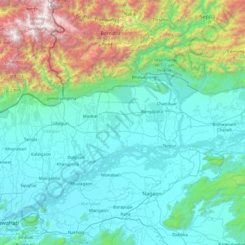
名称:Darrang地形图、海拔、地势。
地点:Darrang, Sonitpur District, Assam, 784110, India (26.05000 91.80000 27.45000 93.20000)
平均海拔:697 米
最低海拔:43 米
最高海拔:4,451 米
其他地形图
点击地图以查看其地形、其海拔和其地势。
Dhubri
Dhubri District is bounded both by interstate and international borders: West Bengal and Bangladesh in the west; Goalpara and Bogaigoan district of Assam and Garo Hills district of Meghalaya in the east; Kokrajhar district in the north; and Bangladesh and state of Meghalaya in the south. The district is…
平均海拔:52 米