
Cape Town地形图
点击地图以显示海拔。
Cape Town
The Cape Peninsula is 52 km long from Mouille Point in the north to Cape Point in the south, with an area of about 470 km2, and it displays more topographical variety than other similar sized areas in southern Africa, and consequently spectacular scenery. There are diverse low-nutrient soils, large rocky outcrops, scree slopes, a mainly rocky coastline with embayed beaches, and considerable local variation in climatic conditions.
关于这张地图
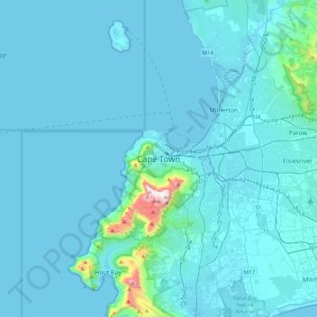
名称:Cape Town地形图、海拔、地势。
平均海拔:53 米
最低海拔:-1 米
最高海拔:1,078 米
其他地形图
点击地图以查看其地形、其海拔和其地势。
Table Mountain
South Africa > Western Cape > City of Cape Town > Cape Town
Table Mountain is at the northern end of a sandstone mountain range that forms the spine of the Cape Peninsula that terminates approximately 50 kilometres (30 mi) to the south at the Cape of Good Hope and Cape Point. Immediately to the south of Table Mountain is a rugged "plateau" at a somewhat lower elevation…
平均海拔:583 米
Durbanville
South Africa > Western Cape > City of Cape Town
Durbanville is situated in the northern suburbs of Cape Town, approximately 28 kilometres (17.4 mi) north-east of the city, bordered by Bellville to the south, Brackenfell to the south-east and Kraaifontein to the east. It lies at an altitude of between 100 m (328 ft) to 240 m (787 ft), in the vast rolling…
平均海拔:157 米
False Bay
South Africa > Western Cape > City of Cape Town
Local variations in wind direction and strength are caused by interaction with the mountains on both sides of the bay. South-easterly winds are accelerated northwest of Cape Hangklip, and a distinct wind shadow can develop in the lee of the Kogelberg mountain. Northwesterly winds accelerate over Table Mountain…
平均海拔:28 米
Table Mountain
South Africa > Western Cape > City of Cape Town > Cape Town
Table Mountain is at the northern end of a sandstone mountain range that forms the spine of the Cape Peninsula that terminates approximately 50 kilometres (30 mi) to the south at the Cape of Good Hope and Cape Point. Immediately to the south of Table Mountain is a rugged "plateau" at a somewhat lower elevation…
平均海拔:578 米
False Bay
South Africa > Western Cape > City of Cape Town
Local variations in wind direction and strength are caused by interaction with the mountains on both sides of the bay. South-easterly winds are accelerated northwest of Cape Hangklip, and a distinct wind shadow can develop in the lee of the Kogelberg mountain. Northwesterly winds accelerate over Table Mountain…
平均海拔:28 米
Table Mountain
South Africa > Western Cape > City of Cape Town > Cape Town
Table Mountain is at the northern end of a sandstone mountain range that forms the spine of the Cape Peninsula that terminates approximately 50 kilometres (30 mi) to the south at the Cape of Good Hope and Cape Point. Immediately to the south of Table Mountain is a rugged "plateau" at a somewhat lower elevation…
平均海拔:583 米
Durbanville
South Africa > Western Cape > City of Cape Town
Durbanville is situated in the northern suburbs of Cape Town, approximately 28 kilometres (17.4 mi) north-east of the city, bordered by Bellville to the south, Brackenfell to the south-east and Kraaifontein to the east. It lies at an altitude of between 100 m (328 ft) to 240 m (787 ft), in the vast rolling…
平均海拔:157 米