Pine Top地形图
点击地图以显示海拔。
关于这张地图
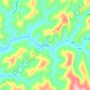
名称:Pine Top地形图、海拔、地势。
地点:Pine Top, Knott County, Kentucky, 41843, United States (37.25260 -82.90238 37.29260 -82.86238)
平均海拔:426 米
最低海拔:328 米
最高海拔:612 米
其他地形图
点击地图以查看其地形、其海拔和其地势。

点击地图以显示海拔。
名称:Pine Top地形图、海拔、地势。
地点:Pine Top, Knott County, Kentucky, 41843, United States (37.25260 -82.90238 37.29260 -82.86238)
平均海拔:426 米
最低海拔:328 米
最高海拔:612 米
点击地图以查看其地形、其海拔和其地势。