
High Cliff地形图
点击地图以显示海拔。
关于这张地图
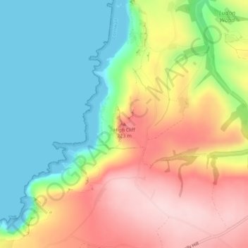
名称:High Cliff地形图、海拔、地势。
地点:High Cliff, Cornwall, England, PL35 0HN, United Kingdom (50.71761 -4.65044 50.71771 -4.65034)
平均海拔:113 米
最低海拔:0 米
最高海拔:258 米
其他地形图
点击地图以查看其地形、其海拔和其地势。
St. John
United Kingdom > England > Cornwall
A few hundred metres north of St John village is an area of high ground called Vanderbands, the site of an Iron Age castle mentioned by John Norden (an English topographer who wrote a series of county histories) in his description of Cornwall published in 1728.
平均海拔:53 米