
Idlewild地形图
点击地图以显示海拔。
关于这张地图
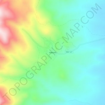
名称:Idlewild地形图、海拔、地势。
地点:Idlewild, Colfax County, New Mexico, 87718, United States (36.52948 -105.32528 36.56948 -105.28528)
平均海拔:2,661 米
最低海拔:2,519 米
最高海拔:2,967 米
其他地形图
点击地图以查看其地形、其海拔和其地势。
Angel Fire
United States > New Mexico > Colfax County
Angel Fire is located in southwestern Colfax County at 36°22′44″N 105°17′8″W / 36.37889°N 105.28556°W / 36.37889; -105.28556 (36.378808, -105.285658). The village center is in the valley of Cieneguilla Creek, with housing developments climbing mountain slopes to the east and west. Angel…
平均海拔:2,786 米
Lake Maloya
United States > New Mexico > Colfax County
Lake Maloya is a reservoir in Sugarite Canyon State Park on the New Mexico-Colorado State border, northeast of Raton, New Mexico. It is the main source of water for the city and its outlying areas. When full, the lake's surface has an elevation of 7,516 feet (2,291 meters).
平均海拔:2,387 米
Angel Fire
United States > New Mexico > Colfax County
Angel Fire is located in southwestern Colfax County. The village center is in the valley of Cieneguilla Creek, with housing developments climbing mountain slopes to the east and west. Angel Fire Resort, entirely within the village limits, is on the east side of the valley, with a base elevation of 8,600 feet…
平均海拔:2,786 米
Raton
United States > New Mexico > Colfax County
Sugarite Canyon State Park is located 12 miles (19 km) northeast of Raton at an elevation of 8,800 feet (2,700 m). Activities there include camping, fishing, and hiking.
平均海拔:2,040 米