
Mitsuke地形图
点击地图以显示海拔。
Mitsuke
The highest elevation is 300 meters above sea level, and the lowest is 10 meters above sea level. Over 50% of the city area is farmland, mostly in the northern part of the city.
关于这张地图
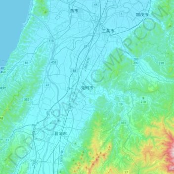
名称:Mitsuke地形图、海拔、地势。
地点:Mitsuke, Niigata Prefecture, Chubu Region, Japan (37.37145 138.75266 37.69145 139.07266)
平均海拔:113 米
最低海拔:-1 米
最高海拔:1,189 米
其他地形图
点击地图以查看其地形、其海拔和其地势。
Okinawa Island
The Motobu Peninsula in the north has limestone layers and karst development. In the center and south is mainly a Ryukyu limestone layer and mudstone. The topography is flat, there are few hills over 100 m (328 ft) with very few rivers. The subtropical rains accelerate erosion so there are many drainages and…
平均海拔:14 米
Hokkaido
Japan's coldest region, Hokkaido has relatively cool summers and icy/snowy winters. Most of the island falls in the humid continental climate zone with Köppen climate classification Dfb (hemiboreal) in most areas but Dfa (hot summer humid continental) in some inland lowlands. The average August temperature…
平均海拔:98 米
Kanagawa Prefecture
Topographically, the prefecture consists of three distinct areas. The mountainous western region features the Tanzawa Mountain Range and the volcano Mount Hakone. The hilly eastern region is characterized by the Tama Hills and Miura Peninsula. The central region, which surrounds the Tama Hills and Miura…
平均海拔:170 米
Iki Island
Iki Island is slightly oval in shape, and measures approximately 17 kilometres (11 mi) from north-south and 14 kilometres (8.7 mi) from east-west. The highest elevation is Takenotsuji (岳ノ辻), a weakly curved peak with a highest elevation at 212.9 metres (698 ft) above sea level. The average height of the…
平均海拔:21 米
Tanegashima Island
The island is of volcanic origin; however, unlike neighboring Yakushima, it presents a flat appearance, with its highest elevation at only 282 metres (925 ft) above sea level. The island has a length of 57 kilometres (31 nmi) and a width ranging from 5 kilometres (2.7 nmi) to 10 kilometres (5.4 nmi). The…
平均海拔:14 米
Tsushima Island
Tsushima is the closest Japanese territory to the Korean Peninsula, lying approximately 50 km from Busan. On a clear day, the hills and mountains of the Korean peninsula are visible from the higher elevations on the two northern mountains. The nearest Japanese port, Iki, situated on Iki Island within the…
平均海拔:16 米
Gokase
Gokase is located in the northwest Miyazaki Prefecture, in the center of the Kyushu Mountains, and borders Kumamoto Prefecture from the northern part of the town to the northwest, west, and southwest. The area is generally high in altitude, with even the hilly area in the north, the center of the town, being…
平均海拔:766 米
Rikubetsu
Rikubetsu (陸別町, Rikubetsu-chō) is a town located in Tokachi Subprefecture, Hokkaido, Japan. It is located on the edge of the Tokachi Plain at an altitude of 207 metres (679 ft) above sea level.
平均海拔:398 米
Koka
Kōka occupies the entire southern end of Shiga Prefecture, and is thus long east-to-west. At the eastern end of Kōka, the southern ridge of the Suzuka Mountains with one elevation of 1000 meters runs from northeast to southwest, forming the boundary with Mie Prefecture. The highest altitude point in Kōka is…
平均海拔:300 米
Nagato
Nagato is located in northwestern Yamaguchi. The north side faces the Sea of Japan, and the coastline facing the open sea is eroded terrain. On the other hand, there are coves such as Fukagawa Bay and Senzaki Bay, which are surrounded by the island of Ōmijima and the mainland, and Aburaya Bay, which is…
平均海拔:71 米
Akusekijima
Japan > Kagoshima County > Toshima
The island is an andesite – dacite stratovolcano formed by two summit craters, Biroyama (ビロ山) 355.5 metres (1,166 ft) and Nakadake (中岳). 464 metres (1,522 ft). Mitake (御岳山) 584 metres (1,916 ft), the highest elevation on the island, is a lava dome. Lava flows in the northern portion of the…
平均海拔:112 米
Takeo
Takeo is located in the western part of Saga Prefecture. It is approximately 28 kilometers (17 mi) west of Saga City and approximately 30 kilometers (19 mi) east of Sasebo. Takeo has a complex topography including mountains, mountain basins and riverside plains. The population is concentrated in the western…
平均海拔:103 米
KIta Hiroshima
Kitahiroshima is in the Chūgoku Mountains of north-central Hiroshima, bordered by Shimane Prefecture to the north. Due to its location and elevation, it is a heavy snowfall region.
平均海拔:424 米
Izenajima
The total area is 15.44 square kilometres (5.96 sq mi), and the peripheral sea coast line is 16 kilometres (9.9 mi). The island's topography features a series of mountains spanning from the northwest to the southeast of the island, with generally flat, arable land covering the remainder. The island has several…
平均海拔:13 米
Kuchinoerabu Island
Japan > Kumage County > Yakushima
Kuchinoerabu-jima is located 130 kilometres (70 nmi) south of Kagoshima. The island is of volcanic origin, and has an area of approximately 38 square kilometres (15 sq mi) with a length of 12 kilometres (7.5 mi) and width of 5 kilometres (3.1 mi). The highest elevations on the island are Furudake (古岳),…
平均海拔:47 米
Tairajima
Japan > Kagoshima County > Toshima
Tairajima is located 32 kilometres (17 nmi) southwest of Nakanoshima, and is the second smallest inhabited islands in the archipelago. The island has an area of approximately 2.08 square kilometres (0.80 sq mi) with a length of about 1.5 kilometres (0.93 mi) and a width of 1.0 kilometre (0.62 mi). The highest…
平均海拔:22 米
Yokoatejima
Japan > Kagoshima County > Toshima
The island is formed by two smaller stratovolcanoes - Higashimine (東峰) to the east, with a maximum elevation of 494.8 metres (1,623 ft) and Nishimine (西峰) to the west, with a maximum elevation of 259 metres (850 ft). The only known volcanic activity on either peak was towards the end of the Edo period,…
平均海拔:47 米
Suwanosejima
Japan > Kagoshima County > Toshima
Suwanosejima is the second largest of the islands in the Tokara archipelago, and is located 21 kilometres (11 nmi) southwest from Nakanoshima. The highest elevation is Otake (御岳), with a height of 796 metres (2,612 ft) above sea level, which is the exposed cone of an active stratovolcano arising from the…
平均海拔:106 米