
Leckie地形图
点击地图以显示海拔。
关于这张地图
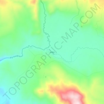
名称:Leckie地形图、海拔、地势。
地点:Leckie, Sublette County, Wyoming, United States (42.55078 -109.29902 42.59078 -109.25902)
平均海拔:2,444 米
最低海拔:2,325 米
最高海拔:2,688 米
其他地形图
点击地图以查看其地形、其海拔和其地势。
Pinedale
United States > Wyoming > Sublette County
Pinedale is located at 42°51′58″N 109°51′53″W / 42.86611°N 109.86472°W / 42.86611; -109.86472 (42.866162, −109.864622) and sits at an elevation of 7,175 feet above sea level. According to the United States Census Bureau, the town has a total area of 2.15 square miles (5.57 km2), all land.
平均海拔:2,196 米
Pinedale
United States > Wyoming > Sublette County
Pinedale is located at 42°51′58″N 109°51′53″W / 42.86611°N 109.86472°W / 42.86611; -109.86472 (42.866162, −109.864622)[8] and sits at an elevation of 7,175 feet above sea level. According to the United States Census Bureau, the town has a total area of 2.15 square miles (5.57 km2), all land.[9]
平均海拔:2,196 米