
Darmstadt地形图
点击地图以显示海拔。
关于这张地图
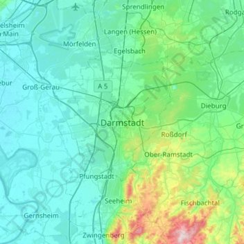
名称:Darmstadt地形图、海拔、地势。
地点:Darmstadt, Hesse, 64283, Germany (49.71278 8.49118 50.03278 8.81118)
平均海拔:151 米
最低海拔:82 米
最高海拔:604 米
其他地形图
点击地图以查看其地形、其海拔和其地势。
Wiesbaden
The highest point of the Wiesbaden municipality is located northwest of the city center near the summit of the Hohe Wurzel, with an elevation of 608 metres (1,995 ft) above sea level. The lowest point is the harbour entrance of Schierstein at 83 metres (272 ft) above sea level. The central square (the…
平均海拔:221 米
Bad Hersfeld
Germany > Hesse > Landkreis Hersfeld-Rotenburg
The Flugplatz Johannesberg has the status of Special Airfield. The runway, some 671 m long and 18 m wide, is paved with asphalt and oriented in a north–south direction. The airfield lies on the Johannesberg in the like-named outlying centre at an elevation of 284 m above sea level.
平均海拔:305 米
Zwingenberg
Germany > Hesse > Kreis Bergstraße
Zwingenberg lies on the western edge of the Odenwald at the foot of the Melibokus, at 517.4 m above sea level the Bergstraße's highest mountain. The municipal area's elevation varies between roughly 90 m above sea level in the outlying centre of Rodau and just under 300 m on the slope of the Melibokus.…
平均海拔:104 米
Freigericht
Germany > Hesse > Main-Kinzig-Kreis
Freigericht has an elevation of 140 to 371 m in a side valley of the Kinzig river.
平均海拔:224 米
Taunus
Hintertaunus is the name given to the area north of the Hoher Taunus up to the Lahn valley. The landscape here is lower and less mountainous than in the southern Taunus. Between the valleys, some of which are quite deep, there are pronounced plateaus (leveled areas) with heavy agricultural use. Since mostly…
平均海拔:280 米
Igstadt
Igstadt is situated on the eastern slope of the Wäschbachtal valley at an elevation of 169 to 211 m above sea level. It is traversed by the Wiesbaden-Niedernhausen rail line. It is surrounded by agricultural land. Recreational areas include the Wickerbachtal Nature Reserve between Igstadt and Kloppenheim.
平均海拔:198 米
Limburg an der Lahn
Germany > Hesse > Landkreis Limburg-Weilburg
The town lies roughly centrally in a basin within the Rhenish Slate Mountains which is surrounded by the low ranges of the Taunus and Westerwald and called the Limburg Basin (Limburger Becken). Owing to the favourable soil and climate, the Limburg Basin stands as one of Hesse's richest agricultural regions and…
平均海拔:163 米
Wetzlar
Germany > Hesse > Lahn-Dill-Kreis
Wetzlar has a year-round temperate seasonal climate of the middle latitudes. Between the different elevations there are different small climatic conditions. The daily mean temperature in summer is about 17 to 18 °C (63 to 64 °F) and in winter about 1 to 2 °C (34 to 36 °F). The average rainfall is 600 to…
平均海拔:228 米
Reichelsheim (Odenwald)
Germany > Hesse > Odenwaldkreis
Reichelsheim lies in the middle Odenwald at elevations between 200 and 538 m in the middle of the Geo-Naturpark Bergstraße-Odenwald.
平均海拔:335 米