点击地图以显示海拔。
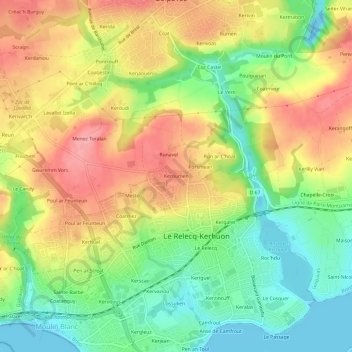
名称:Keroumen地形图、海拔、地势。
地点:Keroumen, Le Relecq-Kerhuon, Brest, Finistère, Bretagne, France métropolitaine, 29480, France (48.39438 -4.42005 48.43438 -4.38005)
平均海拔:51 米
最低海拔:-11 米
最高海拔:106 米
点击地图以查看其地形、其海拔和其地势。
France > Bretagne > Finistère > Le Relecq-Kerhuon
平均海拔:36 米