
Carperby地形图
点击地图以显示海拔。
关于这张地图
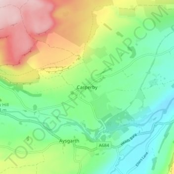
名称:Carperby地形图、海拔、地势。
平均海拔:244 米
最低海拔:135 米
最高海拔:439 米
其他地形图
点击地图以查看其地形、其海拔和其地势。
Harrogate
United Kingdom > England > North Yorkshire
Harrogate is situated on the edge of the Yorkshire Dales, with the Vale of York to the east and the upland Yorkshire Dales to the west and north-west. It has a dry and mild climate, typical of places in the rain shadow of the Pennines. It is on the A59 from Skipton to York. At an altitude of between 100 and…
平均海拔:131 米
North York Moors National Park
United Kingdom > England > North Yorkshire
As part of the United Kingdom, the North York Moors area generally has warm summers and relatively mild winters. Weather conditions vary from day to day as well as from season to season. The latitude of the area means that it is influenced by predominantly westerly winds with depressions and their associated…
平均海拔:110 米
Malham
United Kingdom > England > North Yorkshire
Malham has an Oceanic climate, but is generally colder and wetter than most settlements in Britain. It has a relatively low altitude of around 200 metres, but is partly surrounded by fells. This exposed position means the temperature range is limited, due to little pooling of cold air. Extremes of temperature…
平均海拔:362 米
Scarborough
United Kingdom > England > North Yorkshire
The climate is temperate with mild summers and cool, windy, winters. The hottest months of the year are July and August, with temperatures reaching an average high of 17 °C and falling to 11 °C at night. The average daytime temperatures in January are 4 °C, falling to 1 °C at night. The station's elevation…
平均海拔:50 米
Hovingham
United Kingdom > England > North Yorkshire
The nearest settlements are Slingsby 1.75 miles (2.82 km) to the east; Stonegrave 1.6 miles (2.6 km) to the north; Cawton 1.9 miles (3.1 km) to the north-west; Coulton 2.2 miles (3.5 km) to the west south-west and Scackleton 2.1 miles (3.4 km) to the south-west. The village lies at an elevation of 215 feet (66…
平均海拔:61 米
Hawnby
United Kingdom > England > North Yorkshire
The village sits at the junction of several small roads at the head of two valleys, close to the B1257 road between Oswaldkirk and Stokesley. The nearest settlements are Boltby 3.7 miles (6 km) to the south-west; Old Byland 2.3 miles (3.7 km) to the south and Fangdale Beck 3.4 miles (5.5 km) to the north. It…
平均海拔:258 米
Hebden
United Kingdom > England > North Yorkshire
The name Hebden may be derived from either heope, Old English for a rose-hip or heopa, Old English for a bramble, and dene, Old English for a valley, or from the Scandinavian Hebban, a topographical description of a ridge forming an elevated site above a small valley. Two Bronze Age stone circles and remnants…
平均海拔:329 米
River Derwent
United Kingdom > England > North Yorkshire
Rainfall and climate conditions vary slightly across the Derwent catchment area due to the topography. Annual rainfall ranges from averages of 600 millimetres (24 in) at Barmby Barrage to over 1,100 millimetres (43 in) at its source on the North York Moors.
平均海拔:56 米