
Buford地形图
点击地图以显示海拔。
关于这张地图
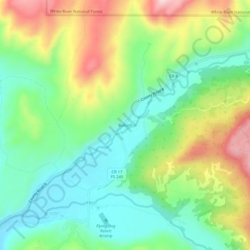
名称:Buford地形图、海拔、地势。
地点:Buford, Rio Blanco County, Colorado, United States (39.96720 -107.63673 40.00720 -107.59673)
平均海拔:2,241 米
最低海拔:2,113 米
最高海拔:2,460 米
其他地形图
点击地图以查看其地形、其海拔和其地势。
Meeker
United States > Colorado > Rio Blanco County
According to the United States Census Bureau, the town has a total area of 2.9 square miles (7.5 km2), all of it land. The town is situated on the White River at an elevation of 6,250 feet above sea level.
平均海拔:2,016 米
Meeker
United States > Colorado > Rio Blanco County
According to the United States Census Bureau, the town has a total area of 2.9 square miles (7.5 km2), all of it land. The town is situated on the White River at an elevation of 6,250 feet above sea level.
平均海拔:2,016 米