
Montrose地形图
点击地图以显示海拔。
Montrose
Montrose occupies a position on the North Bank of Montrose Basin at the mouth of the River South Esk on the East Coast of Scotland, 11 miles (18 km) NNE of Arbroath, 19 miles (31 km) SW of Stonehaven, and 7.2 miles (12 km) ESE of Brechin. The town lies 62.2 miles (100 km) NNE of Edinburgh, and 373.2 miles (601 km) NNW of London. The built-up area occupies a roughly rectangular shape 2 miles (3 km) long by 0.75 miles (1 km) wide, aligned in a north–south orientation. The land is relatively flat, rising gradually to around 15m elevation to the North of the town.
关于这张地图
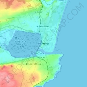
名称:Montrose地形图、海拔、地势。
地点:Montrose, Angus, Scotland, DD10 8JB, United Kingdom (56.67143 -2.50815 56.75143 -2.42815)
平均海拔:22 米
最低海拔:-2 米
最高海拔:135 米
其他地形图
点击地图以查看其地形、其海拔和其地势。