
Lumberton地形图
点击地图以显示海拔。
关于这张地图
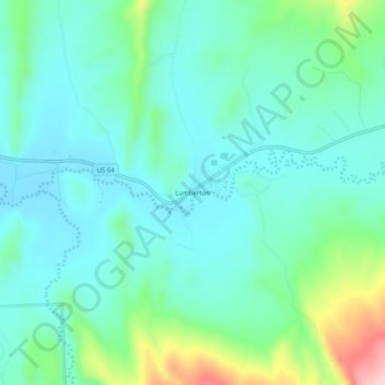
名称:Lumberton地形图、海拔、地势。
地点:Lumberton, Rio Arriba County, New Mexico, United States (36.91007 -106.95673 36.95007 -106.91673)
平均海拔:2,130 米
最低海拔:2,075 米
最高海拔:2,317 米
其他地形图
点击地图以查看其地形、其海拔和其地势。
Dulce
United States > New Mexico > Rio Arriba County
Dulce is the southernmost urban area with a subarctic humid continental climate in North America (Köppen: Dfc) where summer is mild and short due to high altitude and rigorous winter. Going further south than the Dfb in low altitude and in latitude similar to the southern limit of the Dfa in the center of the…
平均海拔:2,179 米
Espanola
United States > New Mexico > Rio Arriba County
Española lies at an elevation of around 5,595 feet (1,705 m) with much variance. It is in a valley nestled between the Jemez and Sangre de Cristo mountain ranges, and the meeting point of three rivers, the Rio Grande, the Rio Chama, and the Rio Santa Cruz.
平均海拔:1,739 米