
Cass地形图
点击地图以显示海拔。
Cass
The topography of the Cass area was formed by repeated glaciation in the Pleistocene, with the valley floor built up by river fans as the glaciers retreated and the nearby Lakes Sarah and Grasmere enclosed by moraines and ice-eroded rocks. Many of the valleys around Cass post-date the retreat of the Poulter Glacier 13,000 years ago, and are caused by erosion.
关于这张地图
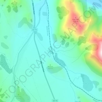
名称:Cass地形图、海拔、地势。
地点:Cass, Selwyn District, Canterbury, New Zealand (-43.05589 171.73641 -43.01589 171.77641)
平均海拔:667 米
最低海拔:515 米
最高海拔:1,213 米
其他地形图
点击地图以查看其地形、其海拔和其地势。