
Wang Tako地形图
点击地图以显示海拔。
关于这张地图
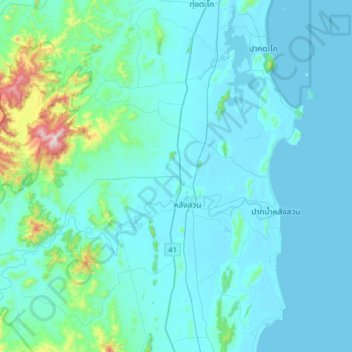
名称:Wang Tako地形图、海拔、地势。
地点:Wang Tako, Chumphon Province, 86110, Thailand (9.81874 98.90417 10.13874 99.22417)
平均海拔:73 米
最低海拔:0 米
最高海拔:763 米
其他地形图
点击地图以查看其地形、其海拔和其地势。
Thailand
Thailand comprises several distinct geographic regions, partly corresponding to the provincial groups. The north of the country is the mountainous area of the Thai highlands, with the highest point being Doi Inthanon in the Thanon Thong Chai Range at 2,565 metres (8,415 ft) elevation. The northeast, Isan,…
平均海拔:156 米
Bangkok
Bangkok is in the Chao Phraya River delta in Thailand's central plain. The river meanders through the city in a southerly direction, emptying into the Gulf of Thailand approximately 25 kilometres (16 mi) south of city centre. The area is flat and low-lying, with an average elevation of 1.5 metres (4 ft 11 in)…
平均海拔:3 米
Ko Pha Ngan
Due to its topography, the population hugs the coastline. The mountainous interior is generally inaccessible. More than half the island designated as national park and Ko Pha-ngan has more than 80 km2 (31 sq mi) of relatively unspoiled rain forest with diverse flora and fauna. It is also considered a spiritual…
平均海拔:84 米
Bangkok
Bangkok is situated in the Chao Phraya River delta in Thailand's central plain. The river meanders through the city in a southerly direction, emptying into the Gulf of Thailand approximately 25 kilometres (16 mi) south of city centre. The area is flat and low-lying, with an average elevation of 1.5 metres (4…
平均海拔:3 米
Phuket Province
Although some recent geographical works refer to the sections of the Tenasserim Hills in the isthmus as the "Phuket Range", these names are not found in classical geographic sources. Besides, the name Phuket is relatively recent having previously been named Jung Ceylon and Thalang. The highest elevation of the…
平均海拔:5 米
Chachoengsao Province
The western part of the province is the low river plain of the Bang Pa Kong River, which is used extensively for farming rice. To the east is hillier terrain, with an average elevation of more than 100 metres. In Tha Takiap District is the Khao Ang Rue Nai Wildlife Sanctuary with an area of 674,352 rai ~ 1,078…
平均海拔:70 米
Prachuap Khiri Khan Province
Prachuap Khiri Khan covers an area totaling 6,367 square kilometers (2,458 sq mi). The province is on the Kra Isthmus, the narrow land bridge connecting the Malay Peninsula with mainland Asia. The province has one of the narrowest parts of Thailand, just 12.38 km (7.69 mi) from the Gulf of Thailand to the…
平均海拔:106 米
Nakhon Nayok Province
The northern part of the province is in the Sankamphaeng Range, the southern prolongation of the Dong Phaya Yen Mountains, with the highest elevation the 1,292-meter-high Yod Khao Kiew. Most of that area is covered by the Khao Yai National Park, 2,166 km2 (836 sq mi), along with three other national parks,…
平均海拔:183 米
Khon Kaen City Municipality
Thailand > Mueang Khon Kaen District
Khon Kaen is on the Khorat Plateau, elevation 187 m, and is the center of the mid-northeastern provincial group of Thailand, according to the Thai government. Its coordinates are 16°26′N 102°50′E / 16.433°N 102.833°E / 16.433; 102.833. The city municipality has a population of 114,459, while…
平均海拔:163 米
Chao Phraya River
The landscape of the river basins is a very wide, flat, well-watered plain continuously refreshed with soil and sediment brought down by the rivers. The lower central plain from the delta north to Ang Thong Province is a flat, low area with an average of two metres above sea level. Further north and into the…
平均海拔:93 米
Kanchanaburi Province
The province is in the west of Thailand, 129 km from Bangkok, and covers a total area of approximately 19,482 km2 (7,522 sq mi). It is the country's third largest province, after Nakhon Ratchasima and Chiang Mai. Topographically, it is covered with timber and evergreen forests. The total forest area is 11,990…
平均海拔:297 米
Bangkok
Bangkok is in the Chao Phraya River delta in Thailand's central plain. The river meanders through the city in a southerly direction, emptying into the Gulf of Thailand approximately 25 kilometres (16 mi) south of city centre. The area is flat and low-lying, with an average elevation of 1.5 metres (4 ft 11 in)…
平均海拔:3 米
Bangkok
Bangkok is situated in the Chao Phraya River delta in Thailand's central plain. The river meanders through the city in a southerly direction, emptying into the Gulf of Thailand approximately 25 km (16 mi) south of the city centre. The area is flat and low-lying, with an average elevation of 1.5 m (4 ft 11 in)…
平均海拔:2 米