
Superior地形图
点击地图以显示海拔。
关于这张地图
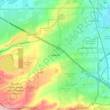
名称:Superior地形图、海拔、地势。
地点:Superior, Boulder County, Colorado, 80027, United States (39.91276 -105.20860 39.99276 -105.12860)
平均海拔:1,689 米
最低海拔:1,607 米
最高海拔:1,832 米
其他地形图
点击地图以查看其地形、其海拔和其地势。
Boulder
United States > Colorado > Boulder County
Boulder is located at the base of the foothills of the Rocky Mountains, at an elevation of 5,430 feet (1,655 m) above sea level. The city is 25 miles (40 km) northwest of the Colorado state capital of Denver. Boulder is a college town, hosting the University of Colorado Boulder, the flagship and largest campus…
平均海拔:1,800 米
Longmont
United States > Colorado > Boulder County
The elevation at City Hall is 4,978 feet (1,517 m) above sea level. St. Vrain Creek, a tributary of the South Platte River, flows through the city just south of the city center.
平均海拔:1,534 米