
Diktel地形图
点击地图以显示海拔。
Diktel
Diktel was renamed to Rupakot Majhuwagadhi on 10 March 2017 after merging some more VDCs. The municipality is divided into 15 wards. It is on 700 m to 2250 m of elevation from sea level. The area of the municipality is 246.51 km2. There are 10,050 households with population of 46,903. By 2020, the name commonly used name Diktel was re-added to the municipality's official name.
关于这张地图
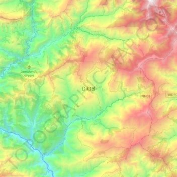
名称:Diktel地形图、海拔、地势。
地点:Diktel, Rupakot Majhuwagadhi, Khotang, Koshi Province, Nepal (27.19328 86.77318 27.23328 86.81318)
平均海拔:1,492 米
最低海拔:1,033 米
最高海拔:2,012 米
其他地形图
点击地图以查看其地形、其海拔和其地势。