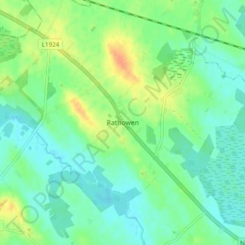
地理定位

Rathowen地形图

点击地图以显示海拔

关于这张地图

名称Rathowen地形图、海拔、地势。

地点Rathowen, The Municipal District of Athlone — Moate, County Westmeath, Leinster, Ireland (53.63540 -7.53972 53.67540 -7.49972)

平均海拔:71 米

最低海拔:59 米

最高海拔:95 米

其他地形图

点击地图以查看其地形、其海拔和其地势

Ballymore

Ireland > County Westmeath

平均海拔:81 米

Portlick

Ireland > County Westmeath

平均海拔:46 米

Ballynacarrigy

Ireland > County Westmeath

平均海拔:71 米

Kilbeggan

Ireland > County Westmeath

平均海拔:71 米

Kilbeggan

Ireland > County Westmeath

平均海拔:71 米

Nahod More

Ireland > County Westmeath

平均海拔:89 米

River Brosna

Ireland > County Westmeath > Mullingar

平均海拔:100 米

Silver

Ireland > County Westmeath

平均海拔:67 米

Nure Bog

Ireland > County Westmeath

平均海拔:85 米

Knockmant

Ireland > County Westmeath

平均海拔:96 米

Silver

Ireland > County Westmeath

平均海拔:67 米

Raharney

Ireland > County Westmeath

平均海拔:79 米

Gallstown

Ireland > County Westmeath

平均海拔:92 米

Collinstown

Ireland > County Westmeath

平均海拔:108 米

Ballymore

Ireland > County Westmeath

平均海拔:81 米

Simonstown

Ireland > County Westmeath

平均海拔:112 米

Dungolman River

Ireland > County Westmeath

平均海拔:58 米

Rathconrath

Ireland > County Westmeath

平均海拔:121 米

Clondardis

Ireland > County Westmeath

平均海拔:112 米

Delvin

Ireland > County Westmeath

平均海拔:89 米

Street

Ireland > County Westmeath

平均海拔:73 米

Knockdrin

Ireland > County Westmeath

平均海拔:98 米

Collinstown

Ireland > County Westmeath

平均海拔:108 米

Multyfarnham

Ireland > County Westmeath

平均海拔:81 米

Battstown

Ireland > County Westmeath

平均海拔:94 米

Kinnegad

Ireland > County Westmeath

平均海拔:75 米

Athlone

Ireland > County Westmeath

平均海拔:43 米

Lough Sheever

Ireland > County Westmeath

平均海拔:98 米

Clonkill

Ireland > County Westmeath

平均海拔:115 米

Hiskinstown

Ireland > County Westmeath

平均海拔:85 米

Rathconrath

Ireland > County Westmeath

平均海拔:121 米

Ballymore

Ireland > County Westmeath

平均海拔:83 米

Athlone

Ireland > County Westmeath

平均海拔:43 米

Lough Bane

Ireland > County Westmeath

平均海拔:130 米

Lough Sewdy

Ireland > County Westmeath

平均海拔:86 米

Kilbixy

Ireland > County Westmeath

平均海拔:67 米

Ardnurcher

Ireland > County Westmeath

平均海拔:71 米

Ballyloughloe

Ireland > County Westmeath

平均海拔:72 米

Tyrrellspass

Ireland > County Westmeath

平均海拔:100 米

Dysart

Ireland > County Westmeath

平均海拔:84 米

Glassan

Ireland > County Westmeath

平均海拔:57 米

Lough Bane

Ireland > County Westmeath

平均海拔:66 米

Rochfortbridge

Ireland > County Westmeath

平均海拔:90 米

Moate

Ireland > County Westmeath

平均海拔:76 米

Toberclare

Ireland > County Westmeath

平均海拔:62 米

Castlelost

Ireland > County Westmeath

平均海拔:93 米

Banagher

Ireland > County Westmeath

平均海拔:96 米

Simonstown

Ireland > County Westmeath

平均海拔:112 米

Kinnegad

Ireland > County Westmeath > Kinnegad

平均海拔:75 米

Kiltoom

Ireland > County Westmeath

平均海拔:80 米

Muckanagh

Ireland > County Westmeath

平均海拔:38 米

Milltown

Ireland > County Westmeath

平均海拔:84 米

Simonstown

Ireland > County Westmeath > Simonstown

平均海拔:80 米

Clonmoyle

Ireland > County Westmeath

平均海拔:108 米

Kilbeggan

Ireland > County Westmeath

平均海拔:71 米

Clonmore

Ireland > County Westmeath

平均海拔:54 米

Griffinstown

Ireland > County Westmeath

平均海拔:83 米

Paslicktown

Ireland > County Westmeath

平均海拔:104 米

Balrath

Ireland > County Westmeath

平均海拔:128 米

Ballykilroe

Ireland > County Westmeath

平均海拔:89 米

Ballynaskeagh

Ireland > County Westmeath

平均海拔:90 米

Adamstown

Ireland > County Westmeath

平均海拔:128 米

Mullingar

Ireland > County Westmeath

平均海拔:99 米

Garrycastle

Ireland > County Westmeath

平均海拔:49 米