
Mareeba地形图
点击地图以显示海拔。
Mareeba
Mareeba has a tropical savanna climate (Köppen: Aw), with a short, hot wet season from December to March and a lengthy, warm dry season from April to November. Due to its elevation, average minima are lowered: ranging from 14.0 °C (57.2 °F) in August to 21.5 °C (70.7 °F) in January to February. In addition, due to being in a rain shadow, average annual rainfall is only 875.9 mm (34.48 in). Despite Mareeba township's tagline reading "300 sunny days a year", and its reputation as a sunny place, Mareeba only receives 86.2 clear days annually. Extreme temperatures have ranged from 40.7 °C (105.3 °F) on 5 January 1994 to 0.4 °C (32.7 °F) on 28 June 1963.
关于这张地图
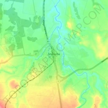
名称:Mareeba地形图、海拔、地势。
地点:Mareeba, Mareeba Shire, Queensland, 4880, Australia (-17.03323 145.38243 -16.95323 145.46243)
平均海拔:410 米
最低海拔:380 米
最高海拔:461 米
其他地形图
点击地图以查看其地形、其海拔和其地势。
City of Brisbane
Brisbane's topography is characterized by a series of hills and ranges that define its landscape. The city is situated on a low-lying floodplain, with the Brisbane River meandering through its heart, creating a winding course with many steep curves from the southwest to its mouth at Moreton Bay in the east.…
平均海拔:71 米
Sunshine Coast Regional
The Sunshine Coast Regional area in Queensland, Australia, features a diverse topography that ranges from coastal plains to rugged hinterlands. Along the coastline, the terrain is predominantly flat, with average elevations around 20 meters (66 feet) above sea level. Inland, the landscape transitions to…
平均海拔:56 米
Brisbane River
The RAAF also perform a practice session in the days preceding the event, serving as an opportunity to both practice beforehand and also promote Riverfire. One of the most popular RAAF aircraft to perform at Riverfire was the F-111 which was known for performing a 'dump-and-burn' above the city. The final…
平均海拔:235 米
City of Brisbane
Brisbane's topography is characterized by a series of hills and ranges that define its landscape. The city is situated on a low-lying floodplain, with the Brisbane River meandering through its heart, creating a winding course with many steep curves from the southwest to its mouth at Moreton Bay in the east.…
平均海拔:71 米
Lamb Island
Australia > Queensland > Brisbane
The island is in the southern part of Moreton Bay between the Queensland mainland and North Stradbroke Island. It is within the Moreton Bay Marine Park. The elevation ranges from 0 to 26 metres (0 to 85 ft) above sea level. The land use on the island is predominantly residential.
平均海拔:4 米