
Pannaikadu地形图
点击地图以显示海拔。
关于这张地图
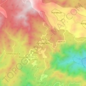
名称:Pannaikadu地形图、海拔、地势。
地点:Pannaikadu, Kodaikanal, Dindigul, Tamil Nadu, 624210, India (10.24171 77.59049 10.32171 77.67049)
平均海拔:1,288 米
最低海拔:385 米
最高海拔:2,058 米
其他地形图
点击地图以查看其地形、其海拔和其地势。
Kodaikanal
India > Tamil Nadu > Kodaikanal
Kodaikanal (Tamil: [ko'ɖaɪ'kaːnəl]) (English: ko-DYE-KAH-null) is a municipality and hill station in Dindigul district in the state of Tamil Nadu, India. It is situated at an altitude of 2,225 m (7,300 ft) in the Palani hills of the Western Ghats. Kodaikanal was established in 1845 to serve as a refuge…
平均海拔:1,976 米
Kodaikanal
India > Tamil Nadu > Kodaikanal
Kodaikanal (Tamil: [ko'ɖaɪ'kaːnəl]) (English: ko-DYE-KAH-null) is a town and hill station in Dindigul district in the state of Tamil Nadu, India. It is situated at an altitude of 2,225 m (7,300 ft) in the Palani hills of the Western Ghats. Kodaikanal was established in 1845 to serve as a refuge from the…
平均海拔:1,976 米
Kodaikanal
India > Tamil Nadu > Kodaikanal
Kodaikanal has a monsoon-influenced subtropical highland climate (Cfb, according to the Köppen climate classification, with a Cwb tendency). The temperatures are cool throughout the year due to the high elevation of the city.
平均海拔:1,958 米