
Pepper Mountain地形图
点击地图以显示海拔。
关于这张地图
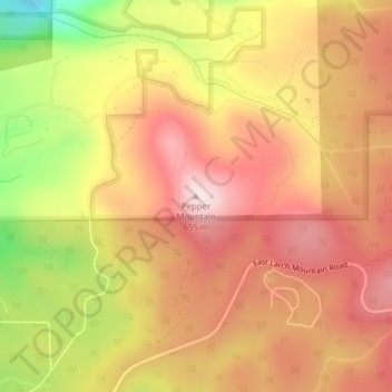
名称:Pepper Mountain地形图、海拔、地势。
地点:Pepper Mountain, Multnomah County, Oregon, United States (45.52729 -122.17347 45.52739 -122.17337)
平均海拔:500 米
最低海拔:252 米
最高海拔:651 米
其他地形图
点击地图以查看其地形、其海拔和其地势。
Portland
United States > Oregon > Multnomah County
Portland features a striking and varied topography characterized by its location at the confluence of the Willamette and Columbia Rivers. The city lies within the fertile Willamette Valley, flanked by the snow-capped Cascade Mountains to the east, including the prominent Mount Hood, and the less elevated…
平均海拔:77 米
Portland
United States > Oregon > Multnomah County
Annual snowfall in Portland is 4.3 inches (10.9 cm), which usually falls between December and March. The city of Portland avoids snow more frequently than its suburbs, due in part to its low elevation and the urban heat island effect. Neighborhoods outside of the downtown core, especially in slightly higher…
平均海拔:77 米
Gresham
United States > Oregon > Multnomah County
Though much of Gresham is relatively flat, it is characterized by a hill on its eastern border. Northeast Gresham is also hilly, particularly where the city meets Troutdale toward the Columbia River. Its elevation is 325 feet (99 m). Johnson Creek, which begins at the foothills of the Cascade Mountains, runs…
平均海拔:90 米
Portland
United States > Oregon > Multnomah County
Annual snowfall in Portland is 4.3 inches (10.9 cm), which usually falls during the December-to-March time frame. The city of Portland avoids snow more frequently than its suburbs, due in part to its low elevation and urban heat island effect. Neighborhoods outside of the downtown core, especially in slightly…
平均海拔:77 米
Portland
United States > Oregon > Multnomah County
Annual snowfall in Portland is 4.3 inches (10.9 cm), which usually falls between December and March. The city of Portland avoids snow more frequently than its suburbs, due in part to its low elevation and the urban heat island effect. Neighborhoods outside of the downtown core, especially in slightly higher…
平均海拔:77 米
Hoyt Arboretum
United States > Oregon > Multnomah County > Portland
Hoyt Arboretum is sited on steep slopes, straddling the SW Fairview Boulevard ridge above the Oregon Zoo and the Portland Japanese Garden. The elevation of the arboretum ranges from 650 feet to 900 feet, and there are several ravines within the arboretum. The hilly terrain of the arboretum was once in private…
平均海拔:209 米
Gresham
United States > Oregon > Multnomah County
Gresham is characterized by hills on its eastern border. Northeast Gresham is also hilly, especially where the city meets Troutdale toward the Columbia River. Its elevation is 325 feet (99 m). Johnson Creek, which begins at the foothills of the Cascade Mountains, runs westward through Gresham, with 23 percent…
平均海拔:89 米
Portland
United States > Oregon > Multnomah County
Annual snowfall in Portland is 4.3 inches (10.9 cm), which usually falls between December and March. The city of Portland avoids snow more frequently than its suburbs, due in part to its low elevation and the urban heat island effect. Neighborhoods outside of the downtown core, especially in slightly higher…
平均海拔:77 米
Portland
United States > Oregon > Multnomah County
Annual snowfall in Portland is 4.3 inches (10.9 cm), which usually falls during the December-to-March time frame. The city of Portland avoids snow more frequently than its suburbs, due in part to its low elevation and urban heat island effect. Neighborhoods outside of the downtown core, especially in slightly…
平均海拔:77 米
Portland
United States > Oregon > Multnomah County
Annual snowfall in Portland is 4.3 inches (10.9 cm), which usually falls between December and March. The city of Portland avoids snow more frequently than its suburbs, due in part to its low elevation and the urban heat island effect. Neighborhoods outside of the downtown core, especially in slightly higher…
平均海拔:77 米
Gresham
United States > Oregon > Multnomah County
Though much of Gresham is relatively flat, it is characterized by a hill on its eastern border. Northeast Gresham is also hilly, particularly where the city meets Troutdale toward the Columbia River. Its elevation is 325 feet (99 m). Johnson Creek, which begins at the foothills of the Cascade Mountains, runs…
平均海拔:90 米