
Green Bay Terrace地形图
点击地图以显示海拔。
关于这张地图
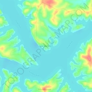
名称:Green Bay Terrace地形图、海拔、地势。
地点:Green Bay Terrace, Camden County, Missouri, United States (38.07281 -92.78185 38.11281 -92.74185)
平均海拔:217 米
最低海拔:196 米
最高海拔:286 米
其他地形图
点击地图以查看其地形、其海拔和其地势。
Linn Creek
United States > Missouri > Camden County
In 1929, it was announced that the Bagnell Dam would be constructed and the town would be flooded, causing controversy among the city's citizens. Almost all of the buildings were demolished, and the city was moved to a higher elevation, losing its designation as the county seat. The location where Linn Creek…
平均海拔:250 米