
Monterey地形图
点击地图以显示海拔。
Monterey
During winter, snow occasionally falls in the higher elevations of the Santa Lucia Mountains and Gabilan Mountains that overlook Monterey, but snow in Monterey itself is extremely rare. A few unusual events in January 1962, February 1976, and December 1997 brought a light coating of snow to Monterey. In March 2006, a total of 3.2 inches (8.1 cm) fell in Monterey, including 2.2 inches (5.6 cm) on March 10, 2006. The snowfall on January 21, 1962, of 1.5 inches (3.8 cm), is remembered for delaying the Bing Crosby golf tournament in nearby Pebble Beach.
关于这张地图
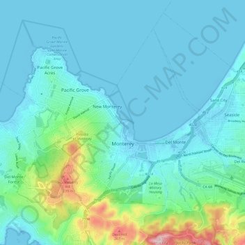
名称:Monterey地形图、海拔、地势。
地点:Monterey, Monterey County, California, United States (36.57155 -121.92667 36.64510 -121.80811)
平均海拔:50 米
最低海拔:-7 米
最高海拔:312 米
其他地形图
点击地图以查看其地形、其海拔和其地势。
David Cutino Park
United States > California > Monterey County > Seaside > Del Monte Heights
平均海拔:35 米
Lockwood
United States > California > Monterey County
Lockwood is in southern Monterey County, 6 miles (10 km) east-southeast of Jolon, 1.8 miles (2.9 km) north of the mouth of Tule Canyon, 3.0 miles (4.8 km) north of the San Antonio River, and 9.3 miles (15.0 km) north of Bryson, at an elevation of 971 feet (296 m). It is 9 miles (14 km) northwest of Lake San…
平均海拔:307 米
Posts
United States > California > Monterey County
Posts (formerly Posts Summit) is an unincorporated community in the Big Sur region of Monterey County, California. It is located on the Big Sur Coast Highway, 4.8 miles (7.7 km) south of the Big Sur Village at an elevation of 945 feet (288 m).
平均海拔:251 米
Big Sur
United States > California > Monterey County
The highest peaks of the crest of the coast range are located at an average distance from the coast of three and a half miles [5.6 km]. In this distance they rise to elevations of from three thousand six hundred to five thousand feet [1,100 to 1,500 m] above the sea-level. From San Carpoforo Creek to…
平均海拔:193 米
Gorda
United States > California > Monterey County
Gorda (Spanish for "Fat") is a hamlet in Monterey County, California. It is located 3 mi (4.8 km) south of Cape San Martin, at an elevation of 148 ft (45 m). It is one of the three small settlements of filling stations, restaurants, and motels located along State Route 1 on the Big Sur coast. The ZIP Code is…
平均海拔:168 米
Big Sur
United States > California > Monterey County
The highest peaks of the crest of the coast range are located at an average distance from the coast of three and a half miles [5.6 km]. In this distance they rise to elevations of from three thousand six hundred to five thousand feet [1,100 to 1,500 m] above the sea-level. From San Carpoforo Creek to…
平均海拔:193 米
Las Lomas
United States > California > Monterey County > Las Lomas > Hutchings Gate
Las Lomas (Spanish for 'The Hills') is an unincorporated community and census-designated place (CDP) in Monterey County, California, United States. Las Lomas is located 7 miles (11 km) north-northwest of Prunedale. The elevation is 43 feet (13 m). The population was 3,046 at the 2020 census.
平均海拔:35 米
Prunedale
United States > California > Monterey County
Prunedale is a census-designated place in Monterey County, California, United States. It is located 8 miles (13 km) north of Salinas at an elevation of 92 feet (28 m). The population was 18,885 as of the 2020 census, up from 17,560 in 2010. Plum trees were grown in Prunedale in the early days of its founding,…
平均海拔:69 米
King City
United States > California > Monterey County
King City (variants: Kings City, City of King) is a city in Monterey County, California, United States. It is located on the Salinas River 51 miles (82 km) southeast of Salinas, at an elevation of 335 feet (102 m). It lies along U.S. Route 101 in the Salinas Valley of California's Central Coast. King City is a…
平均海拔:102 米