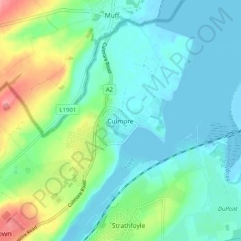
点击地图以显示海拔。
名称:Culmore地形图、海拔、地势。
地点:Culmore, County Londonderry, Northern Ireland, BT48 8JN, United Kingdom (55.02993 -7.28670 55.06993 -7.24670)
平均海拔:22 米
最低海拔:-3 米
最高海拔:86 米
点击地图以查看其地形、其海拔和其地势。
United Kingdom > Northern Ireland > County Londonderry
平均海拔:47 米
平均海拔:101 米
平均海拔:112 米
United Kingdom > Northern Ireland > County Londonderry > Derry/Londonderry
平均海拔:19 米
平均海拔:46 米
平均海拔:21 米
平均海拔:73 米
平均海拔:33 米
United Kingdom > Northern Ireland > County Londonderry > Londonderry/Derry
平均海拔:61 米