
Ghazni地形图
点击地图以显示海拔。
Ghazni
Ghazni's climate is transitional between a cold semi-arid climate (Köppen climate classification BSk) and a hot-summer humid continental climate (Dsa). It has cold, snowy winters and warm, dry summers. Precipitation is low and mostly falls in winter (as snow) and spring (as rain). Winters are very cold, with a subzero January daily average temperature of −5.9 °C (21.4 °F), mainly due to the high elevation of the city.
关于这张地图
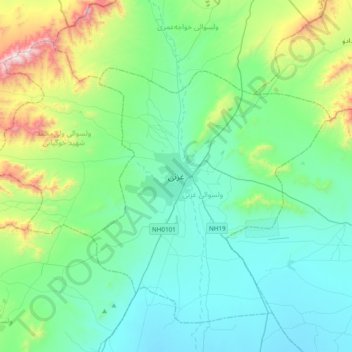
名称:Ghazni地形图、海拔、地势。
地点:Ghazni, Ghazni Province, Afghanistan (33.38490 68.25321 33.70490 68.57321)
平均海拔:2,341 米
最低海拔:2,093 米
最高海拔:3,340 米
其他地形图
点击地图以查看其地形、其海拔和其地势。