点击地图以显示海拔。
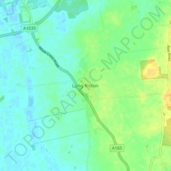
名称:Long Riston地形图、海拔、地势。
地点:Long Riston, East Riding of Yorkshire, Hull and East Yorkshire, England, HU11 5JZ, United Kingdom (53.84559 -0.31035 53.88559 -0.27035)
平均海拔:8 米
最低海拔:-2 米
最高海拔:23 米
点击地图以查看其地形、其海拔和其地势。
United Kingdom > England > East Riding of Yorkshire
平均海拔:13 米
United Kingdom > England > East Riding of Yorkshire > Walkington
平均海拔:76 米
平均海拔:23 米
平均海拔:28 米
平均海拔:15 米
平均海拔:10 米
平均海拔:17 米
平均海拔:18 米
平均海拔:3 米
United Kingdom > England > East Riding of Yorkshire > Ellerker
United Kingdom > England > East Riding of Yorkshire > South Cave
平均海拔:38 米
United Kingdom > England > East Riding of Yorkshire > Brandesburton
平均海拔:43 米
平均海拔:35 米
平均海拔:9 米
United Kingdom > England > East Riding of Yorkshire > Withernsea
平均海拔:5 米
平均海拔:7 米
平均海拔:2 米
平均海拔:4 米
平均海拔:59 米
United Kingdom > England > East Riding of Yorkshire > Stamford Bridge
平均海拔:16 米
平均海拔:72 米
United Kingdom > England > East Riding of Yorkshire > Bugthorpe
平均海拔:54 米
平均海拔:45 米
平均海拔:25 米
平均海拔:89 米
United Kingdom > England > East Riding of Yorkshire > Hollym
平均海拔:58 米
平均海拔:30 米
平均海拔:99 米
United Kingdom > England > East Riding of Yorkshire > Wawne
United Kingdom > England > East Riding of Yorkshire > West Newton
平均海拔:6 米
United Kingdom > England > East Riding of Yorkshire > Kirk Ella
平均海拔:42 米
United Kingdom > England > East Riding of Yorkshire > Warter
平均海拔:126 米
United Kingdom > England > East Riding of Yorkshire > Hotham
平均海拔:27 米
United Kingdom > England > East Riding of Yorkshire > Atwick
United Kingdom > England > East Riding of Yorkshire > Full Sutton
平均海拔:21 米
United Kingdom > England > East Riding of Yorkshire > Brantingham
平均海拔:51 米
United Kingdom > England > East Riding of Yorkshire > Coniston
平均海拔:14 米
平均海拔:62 米
United Kingdom > England > East Riding of Yorkshire > Wetwang
平均海拔:102 米
United Kingdom > England > East Riding of Yorkshire > Bempton
United Kingdom > England > East Riding of Yorkshire > Beeford
平均海拔:11 米
United Kingdom > England > East Riding of Yorkshire > Burton Pidsea
平均海拔:156 米
平均海拔:56 米
United Kingdom > England > East Riding of Yorkshire > Barmby on the Marsh
United Kingdom > England > East Riding of Yorkshire > Bishop Burton
平均海拔:69 米
United Kingdom > England > East Riding of Yorkshire > Market Weighton
平均海拔:87 米
United Kingdom > England > East Riding of Yorkshire > North Cave
United Kingdom > England > East Riding of Yorkshire > Wilberfoss
United Kingdom > England > East Riding of Yorkshire > Hedon
United Kingdom > England > East Riding of Yorkshire > Yapham
平均海拔:39 米
平均海拔:34 米
平均海拔:12 米
平均海拔:33 米
平均海拔:88 米
平均海拔:131 米