Milford地形图
点击地图以显示海拔。
关于这张地图
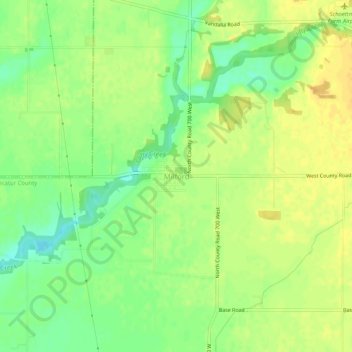
名称:Milford地形图、海拔、地势。
地点:Milford, Decatur County, Indiana, United States (39.33024 -85.63823 39.37024 -85.59823)
平均海拔:258 米
最低海拔:241 米
最高海拔:270 米
其他地形图
点击地图以查看其地形、其海拔和其地势。

点击地图以显示海拔。
名称:Milford地形图、海拔、地势。
地点:Milford, Decatur County, Indiana, United States (39.33024 -85.63823 39.37024 -85.59823)
平均海拔:258 米
最低海拔:241 米
最高海拔:270 米
点击地图以查看其地形、其海拔和其地势。