Avilla地形图
点击地图以显示海拔。
关于这张地图
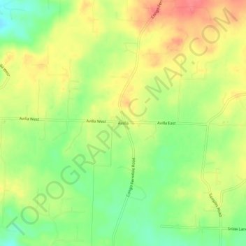
名称:Avilla地形图、海拔、地势。
地点:Avilla, Saline County, Arkansas, United States (34.66259 -92.60516 34.70259 -92.56516)
平均海拔:154 米
最低海拔:122 米
最高海拔:183 米
其他地形图
点击地图以查看其地形、其海拔和其地势。

点击地图以显示海拔。
名称:Avilla地形图、海拔、地势。
地点:Avilla, Saline County, Arkansas, United States (34.66259 -92.60516 34.70259 -92.56516)
平均海拔:154 米
最低海拔:122 米
最高海拔:183 米
点击地图以查看其地形、其海拔和其地势。