
Montpelier地形图
点击地图以显示海拔。
关于这张地图
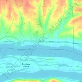
名称:Montpelier地形图、海拔、地势。
地点:Montpelier, Muscatine County, Iowa, 52759, United States (41.43920 -90.82709 41.47920 -90.78709)
平均海拔:187 米
最低海拔:165 米
最高海拔:235 米
其他地形图
点击地图以查看其地形、其海拔和其地势。
Wilton
United States > Iowa > Muscatine County
According to the United States Census Bureau, the city has a total area of 1.95 square miles (5.05 km2), all land. The city sits at an elevation of 679 feet.
平均海拔:210 米